Mount Kōya
| UNESCO World Heritage site | |
|---|---|
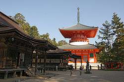 Danjogaran, the central point of Mt. Kōya | |
| Location | Wakayama Prefecture, Japan |
| Part of | Sacred Sites and Pilgrimage Routes in the Kii Mountain Range |
| Criteria | Cultural: ii, iii, iv, vi |
| Reference | 1142 |
| Inscription | 2004 (28th Session) |
| Coordinates | 34°12′45″N 135°35′11″E / 34.21250°N 135.58639°E |
 Location of Mount Kōya in Japan | |
Mount Kōya (高野山 Kōya-san) is the common name of a huge temple settlement in Wakayama Prefecture to the south of Osaka. In the strict sense, Kōya-san is the so-called "mountain name" sangō (山号) of the Kongōbu-Temple (金剛峯寺 Kongōbu-ji), the ecclesiastical headquarters of the "Koyasan Shingon School".[1]
First settled in 819 by the monk Kūkai, Mt. Kōya is primarily known as the world headquarters of the Kōyasan Shingon sect of Japanese Buddhism. Located on an 800 m high plain amid eight peaks of the mountain (which was the reason this location was selected, in that the terrain is supposed to resemble a lotus plant), the original monastery has grown into the town of Kōya, featuring a university dedicated to religious studies and 120 sub-temples, many of which offer lodging to pilgrims. The mountain is home to the following famous sites:
- Kongōbu-ji (金剛峯寺), the head temple of the Kōyasan Shingon Buddhism
- Danjogaran (壇上伽藍), at the heartland of the Mt. Kōya settlement. Garan[2] is a name for an area that has buildings, a main hall, several pagodas, a scripture storage, a bell tower, a lecture hall, and other halls dedicated to important deities. Here we also find a shrine dedicated to the Shintō-gods of that mountain area and in front of it an assembly hall (Sannō-dō) for special ceremonies. Danjō Garan is one of the two sacred spots around the Mount Kōya.[3]
- Okunoin (奥の院), the mausoleum of Kūkai, surrounded by an immense graveyard (the largest in Japan)
- Kōyasan chōishi-michi, the traditional route up the mountain
- Daimon the main gate for Mount Kōya[4]
- It also houses a replica of the Nestorian stele[5]
In 2004, UNESCO designated Mt. Kōya, along with two other locations on the Kii Peninsula, Yoshino and Omine; and Kumano Sanzan, as World Heritage Sites "Sacred Sites and Pilgrimage Routes in the Kii Mountain Range".[6]
The complex includes a memorial hall and cemetery honoring Japanese who were imprisoned or executed for committing atrocities during World War II.[7]
Access
Koya-san is accessible primarily by the Nankai Electric Railway from Namba Station (in Osaka) to Gokurakubashi Station at the base of the mountain. A cable car from Gokurakubashi then whisks visitors to the top in 5 minutes. The entire trip takes about 1.5 hours on an express train or 2 hours by non-express.
Local automobile traffic can be very heavy on weekends until well into the evening. On weekdays, however, the mountain offers a pleasant drive followed by the excitement upon reaching the monasteries lining the summit. Many Buddhist monasteries on the mountain function as hotels for visitors providing traditional accommodation with an evening meal and breakfast.
Gallery
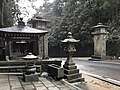 Entrance to Kōya-san with two pillars showing the temple name Kongōbu-ji (Kongōbu Temple) and its mountain name Kōya-san
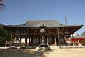 Main Hall (Kondō) of Kongōbu Temple (Danjōgaran)
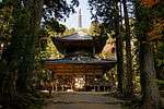 Saitō, West Pagoda (Danjōgaran)
 Tōtō, East Pagoda(Danjōgaran)
 Fudōdo, the hall dedicated to Fudō Myōō (National Treasure)
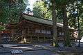 Sanō-in, Hall of the "Mountain King", the local Shintō deity (Danjōgaran)
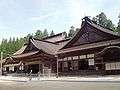 Kongōbu-Temple
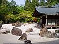 Banryūtei, a rock garden in Kongōbu-Temple
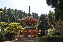 Pagoda of Kongōsanmai-Temple (Kongōsanmai-in), the second oldest "treasure pagoda" in Japan (National Treasure)
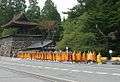 Shingon Buddhist monks, Mt. Kōya, 2004
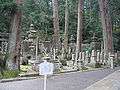 Okunoin Cemetery
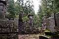 Graves in Okunoin Cemetery
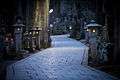 Okunoin Cemetery
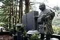 A statue of a deceased pilgrim at his grave site in Okunoin Cemetery
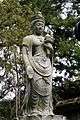 A Kannon-statue in Okunoin Cemetery
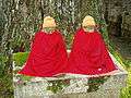 Two Kṣitigarbha-statues (Jizō bosatsu), Okunoin Cemetery
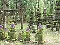 Okunoin Cemetery
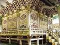 Tokugawa Mausoleum
See also
| Wikimedia Commons has media related to Koyasan. |
| Wikimedia Commons has media related to Okunoin. |
Notes
- ↑ As there are many temples with identical names, Chinese and Japanese temples are traditionally given additional "mountain names". These are no geographical designations. There is no mountain called Kōya-san in Japan.
- ↑ Garan is an abbreviation of sōgyaranma (僧伽藍摩), skr. saMghaaraama सँघाराम), meaning "garden of monks". In Japan it was later used for central areas of big temples such as Kōya-san.
- ↑ "About Mount Koya Danjo Garan - Mount Koya Travel Guide | Planetyze". Planetyze. Retrieved 2017-11-07.
- ↑ "About Daimon - Mount Koya Travel Guide | Planetyze". Planetyze. Retrieved 2017-11-07.
- ↑ Keevak 2008, p. 125
- ↑ Hiragana Times, "Koyasan- A Sacred Tranquility", Volume #294, April 2011, pp. 34-37.
- ↑ Victoria, Brian A., "Mount Koya sites exemplify ‘parallel universe’ where war criminals are martyrs", Japan Times, 5 August 2015
External links
| Wikivoyage has a travel guide for Mount_Koya. |
- Sacred Sites and Pilgrimage Routes in the Kii Mountain Range (UNESCO)
- KONGOBUJI(金剛峰寺)
- Mt. Koya-san JAPAN: the Official Guide
- Koyasan Tourist Association
- Photo set of the Okunoin cemetery of Koyasan (photos under Creative Commons license)
Further reading
Nicoloff, Philip L. (2008). Sacred Koyasan: A pilgrimage to the Mountain Temple of Saint Kōbō Daishi and the Great Sun Buddha. State University of New York Press. ISBN 978-0-7914-7259-0.
Coordinates: 34°12′45″N 135°35′11″E / 34.21250°N 135.58639°E