Kongōbu-ji
| Kongōbu-ji 金剛峰寺 | |
|---|---|
 | |
| Basic information | |
| Location | 132 Kōyasan, Kōya-chō, Ito-gun, Wakayama Prefecture |
| Affiliation | Kōyasan School of Shingon Buddhism |
| Deity | Ashuku Nyorai (Akṣobhya) |
| Country | Japan |
| Website | http://www.shukubo.net/ |
| Architectural description | |
| Founder | Kūkai |
| Completed | 816 |
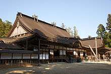
Kongōbu-ji (金剛峯寺) is the ecclesiastic head temple of Koyasan Shingon Buddhism, located on Mount Kōya (高野山 Kōya-san), Wakayama prefecture, Japan. Its name means Temple of the Diamond Mountain Peak. It is part of the "Sacred Sites and Pilgrimage Routes in the Kii Mountain Range" UNESCO World Heritage Site.
The temple was first constructed as Seigan-ji Temple in 1593 by Toyotomi Hideyoshi on the death of his mother, rebuilt in 1861, and given its present name in 1869. It contains many sliding screen doors painted by Kanō Tanyū (1602-1674) and members of the Kyoto Kanō school.
The temple’s modern Banryūtei (蟠龍庭 rock garden) is Japan's largest (2340 square meters), with 140 granite stones arranged to suggest a pair of dragons emerging from clouds to protect the temple.
The 413th abbot of Kongobuji is Reverend Keiho Nakanishi, who also acts as the archbishop of the Koyasan Shingon school.
At the temple, visitors can listen to the sermons of the monks and participate in ajikan meditation sessions. The term ajikan refers to a fundamental breathing and meditation method of Shingon Buddhism: "meditating on the letter A" written using the Siddhaṃ alphabet.[1][2]
Gallery
 Approach
 Fudōdō,
a National Treasure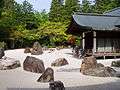 Banryūtei rock garden
 Eight Attendants
 Eight Attendants
 Seitaka Doji
See also
- List of National Treasures of Japan (temples)
- List of National Treasures of Japan (ancient documents)
- List of National Treasures of Japan (paintings)
- List of National Treasures of Japan (sculptures)
- List of National Treasures of Japan (writings)
- List of National Treasures of Japan (crafts-others)
- Tourism in Japan
References
- ↑ "About Kongobuji Temple - Mount Koya Travel Guide | Planetyze". Planetyze. Retrieved 2017-11-29.
- ↑ A page on the Ajikan with references.
- Japan Visitor article
- Wakayama Prefecture article
- Alison Main, Newell Platten, The Lure of the Japanese Garden, W. W. Norton & Company, 2002, page 46. ISBN 0-393-73091-3.
- Dorothy Perkins, Encyclopedia of Japan: Japanese History and Culture, from Abacus to Zori, "Kongobuji" article, Facts on File, 1991, page 182. ISBN 0-8160-1934-7.
External links
| Wikimedia Commons has media related to Kongobuji. |
34°12′51″N 135°35′03″E / 34.214081°N 135.584092°ECoordinates: 34°12′51″N 135°35′03″E / 34.214081°N 135.584092°E