Mount Clef Ridge
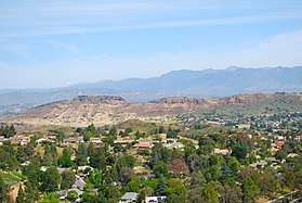
Mount Clef Ridge is a 1,076 ft volcanic mountain in Thousand Oaks, California.[1] It is a volcanic outcrop that resulted from lava eruptions 30 million year ago.[2] The ridge was formerly under ownership by the Janss Corporation, but was acquired by the Conejo Recreation and Park District (CRPD) in 1967.[3][4] Trails here are available from Santa Rosa Valley, Newbury Park and Wildwood Regional Park. Although being a major feature of Wildwood,[5] it occupies its own open-space area bordering Wildwood’s northern boundaries. Mount Clef Ridge Open Space Area occupies 212 acres. From the ridge are great panoramic views of Santa Rosa Valley, Conejo Valley, Hill Canyon, as well as the Santa Susana-, Santa Monica- and Topatopa Mountains.[6] The open-space area is home to plants such as coastal sage scrub, chaparral, Lyon's Pentachaeta and Conejo dudleya. The fauna includes mountain lions, deer, coyotes, gray foxes, and more.[7]
Mount Clef Ridge was featured in the film Flaming Star (1960) starring Elvis Presley.[8]
A rock shelter, known as Wildflower Cave (Ven-486), is located here and was utilized for shelter by the Chumash people in pre-colonial times.[9]
References
- ↑ Stone, Robert (2011). Day Hikes Around Ventura County. Day Hike Books. Page 218. ISBN 9781573420624.
- ↑ Sheer, Julie (2013). Moon Take a Hike Los Angeles: 86 Hikes within Two Hours of the City. Avalon Travel. Page 42. ISBN 9781612381626.
- ↑ http://www.conejo-openspace.org/images/Trail%20Maps/Wildwood_Trail_Map-2pgs_052017.pdf
- ↑ Maulhardt, Jeffrey Wayne (2010). Conejo Valley. Arcadia Publishing. Page 64. ISBN 9780738580395.
- ↑ http://articles.latimes.com/1989-11-25/news/vw-137_1_wildwood-park
- ↑ Stone, Robert (2011). Day Hikes Around Ventura County. Day Hike Books. Page 218. ISBN 9781573420624.
- ↑ http://www.conejo-openspace.org/open_space_areas_in_TO.htm#Mount%20Clef%20Ridge Archived 2016-02-09 at the Wayback Machine.
- ↑ O’Brien, Tricia (2017). Thousand Oaks and Westlake Village. Arcadia Publishing. Page 27. ISBN 9781467125697.
- ↑ Maxwell, Thomas J. (1982). The Temescals of Arroyo Conejo. California Lutheran College. Pages 21-22.
Coordinates: 34°14′04″N 118°53′11″W / 34.23444°N 118.88639°W