Moster
| Moster kommune | |
|---|---|
| Former Municipality | |
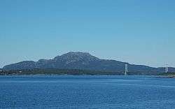 Siggjo and Bømla bridge | |
 Moster kommune Location in Hordaland county | |
| Coordinates: 59°41′57″N 05°23′08″E / 59.69917°N 5.38556°ECoordinates: 59°41′57″N 05°23′08″E / 59.69917°N 5.38556°E | |
| Country | Norway |
| Region | Western Norway |
| County | Hordaland |
| District | Sunnhordland |
| Municipality ID | NO-1218 |
| Adm. Center | Mosterhamn |
| Area[1] | |
| • Total | 66 km2 (25 sq mi) |
| Population (1962) | |
| • Total | 1,841 |
| Time zone | UTC+01:00 (CET) |
| • Summer (DST) | UTC+02:00 (CEST) |
| Created from | Finnås in 1916 |
| Merged into | Bømlo in 1963 |
Moster is a former municipality in Hordaland county, Norway. The municipality existed from 1916 until 1963 when it was merged into the new, larger municipality of Bømlo. The administrative centre of the municipality was the village of Mosterhamn, where the Old Moster Church is located (the oldest surviving stone church in Norway). The 66-square-kilometre (25 sq mi) municipality encompassed the southeastern part of the island of Bømlo and the island of Moster as well as many surrounding islets.[1]
History
The municipality of Moster was established on 1 July 1916 when the old municipality of Finnås was split into the three new municipalities of Moster, Bømlo, and Bremnes. Initially, Moster had a population of 1,316. On 1 January 1963, the three municipalities of Moster, Bømlo, and Bremnes were reunited as the new, larger municipality of Bømlo. Prior to the merger, Moster had a population of 1,834.[2]
References
- 1 2 Store norske leksikon. "Moster – kommune" (in Norwegian). Retrieved 2015-02-16.
- ↑ Jukvam, Dag (1999). "Historisk oversikt over endringer i kommune- og fylkesinndelingen" (PDF) (in Norwegian). Statistisk sentralbyrå.