Mosterhamn
| Mosterhamn Moster | |
|---|---|
| Village | |
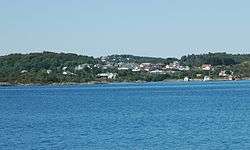 View of the village | |
 Mosterhamn Location in Hordaland county  Mosterhamn Mosterhamn (Norway) | |
| Coordinates: 59°41′57″N 05°23′08″E / 59.69917°N 5.38556°ECoordinates: 59°41′57″N 05°23′08″E / 59.69917°N 5.38556°E | |
| Country | Norway |
| Region | Western Norway |
| County | Hordaland |
| District | Sunnhordland |
| Municipality | Bømlo |
| Area[1] | |
| • Total | 1.75 km2 (0.68 sq mi) |
| Elevation[2] | 2 m (7 ft) |
| Population (2013)[1] | |
| • Total | 1,354 |
| • Density | 774/km2 (2,000/sq mi) |
| Time zone | UTC+01:00 (CET) |
| • Summer (DST) | UTC+02:00 (CEST) |
| Post Code | 5440 Mosterhamn |
Mosterhamn or simply Moster is a village in Bømlo municipality in Hordaland county, Norway. The village is located on the small island of Moster in the southeastern part of the municipality of Bømlo. The village lies along the Bømlafjorden. The 1.75-square-kilometre (430-acre) village has a population (2013) of 1,354; giving the village a population density of 774 inhabitants per square kilometre (2,000/sq mi) and making it the second largest urban area in the municipality.[1][3]
The village is notable since the Old Moster Church is here and that is the site of the Mostratinget, a thing in the year 998 when Olav Tryggvason is said to have brought Christianity to Norway and made it the national Church of Norway.[3]
Prior to the opening of the Triangle Link bridge-tunnel network in 2001, Mosterhamn was one port of the Mosterhamn–Valevåg Ferry which crossed the Bømlafjorden.
References
- 1 2 3 Statistisk sentralbyrå (1 January 2013). "Urban settlements. Population and area, by municipality".
- ↑ "Mosterhamn, Bømlo (Hordaland)" (in Norwegian). yr.no. Retrieved 2015-02-19.
- 1 2 Store norske leksikon. "Mosterhamn" (in Norwegian). Retrieved 2015-02-19.