Morro de São Paulo
| Morro de São Paulo | |
|---|---|
| Village | |
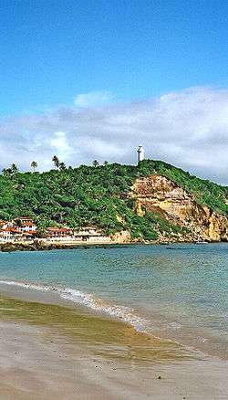 View of Morro de São Paulo, Bahia | |
 Morro de São Paulo Location of Morro de São Paulo in the State of Bahia | |
| Coordinates: 13°22′54″S 38°54′50″W / 13.38167°S 38.91389°WCoordinates: 13°22′54″S 38°54′50″W / 13.38167°S 38.91389°W | |
| Country |
|
| Region | Northeast |
| State |
|
| Time zone | UTC-3 (BRT) |
| Postal Code | 45400000 |
| Website |
www |
Morro de São Paulo (translation: St. Paul's Hill) is one of 5 villages of the island Tinharé in the municipality of Cairu, located in the state of Bahia, Brazil.
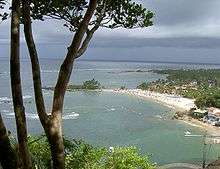
The main beaches of St. Paul's Hill are located on east side of the island as follow: Primeira Praia, Segunda Praia, Terceira Praia, Quarta Praia e Quinta Praia(also known as Praia do Encanto).[1]
History
Martim Afonso de Sousa, landed in 1531 and baptized this island “Tynharéa” and the Bahian accent soon transformed that name to “Tinharé”. In 1535 the village of Morro de São Paulo was founded in the extreme north of the island by Francisco Romero and the local population.
Transportation
The village is 272 km from the city of Salvador by route and 60 km by sea. The only way to get to the island is by boat or by charter flights that go from the airport of Salvador to the local airstrip or by regular flights to Valença Airport.
References
- ↑ "Morro de São Paulo". www.morrodesaopaulo.org.br. Retrieved 2018-03-28.
External links

- Morro de São Paulo Infos about Morro de São Paulo
- (in English) (in French) (in Dutch)