Morriston, Florida
| Morriston, Florida | |
|---|---|
| Census-designated place | |
 Morriston, Florida | |
| Coordinates: 29°16′53″N 82°26′17″W / 29.28139°N 82.43806°WCoordinates: 29°16′53″N 82°26′17″W / 29.28139°N 82.43806°W | |
| Country |
|
| State |
|
| County | Levy |
| Area | |
| • Total | 0.4 sq mi (1.1 km2) |
| • Land | 0.4 sq mi (1.1 km2) |
| • Water | 0 sq mi (0 km2) |
| Elevation | 63 ft (19 m) |
| Population (2010) | |
| • Total | 164 |
| • Density | 390/sq mi (150/km2) |
| Time zone | UTC-5 (Eastern (EST)) |
| • Summer (DST) | UTC-4 (EDT) |
| ZIP code | 32668 |
| FIPS code | 12-46725[1] |
| GNIS feature ID | 287154[2] |
Morriston is a census-designated place (CDP) in Levy County, Florida, United States. The population was 164 at the 2010 census.[3]
Geography
Morriston is located at 29°16′53″N 82°26′17″W / 29.28139°N 82.43806°W[4] in eastern Levy County. U.S. Route 41 forms the west edge of the community, leading north 8 miles (13 km) to Williston and south 17 miles (27 km) to Dunnellon.
According to the United States Census Bureau, the CDP has a total area of 0.42 square miles (1.1 km2), all land.
References
- ↑ "American FactFinder". United States Census Bureau. Retrieved 2008-01-31.
- ↑ "US Board on Geographic Names". United States Geological Survey. 2007-10-25. Retrieved 2008-01-31.
- ↑ "Geographic Identifiers: 2010 Demographic Profile Data (G001): Morriston CDP, Florida". U.S. Census Bureau, American Factfinder. Retrieved December 5, 2012.
- ↑ "US Gazetteer files: 2010, 2000, and 1990". United States Census Bureau. 2011-02-12. Retrieved 2011-04-23.
Municipalities and communities of Levy County, Florida, United States | ||
|---|---|---|
| Cities | 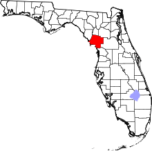 | |
| Towns | ||
| CDPs | ||
| Unincorporated communities | ||
| Footnotes | ‡This populated place also has portions in an adjacent county or counties | |
This article is issued from
Wikipedia.
The text is licensed under Creative Commons - Attribution - Sharealike.
Additional terms may apply for the media files.