Moonee Ponds Creek Trail
| Moonee Ponds Creek Trail | |
|---|---|
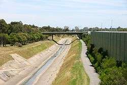 Moonee Ponds Creek Trail running alongside Citylink | |
| Length | Approx 25 km |
| Location | Melbourne, Victoria, Australia |
| Cycling details | |
| Trail difficulty | Easy |
| Hazards | Blind corners, steep drop into creek. There is a gravel bank near Flemington Bridge Station where it is easy to slip |
| Surface | Bitumen path, purpose built wooden decking in spots |
| Hills | Flat |
| Connecting transport | |
| Train(s) | Jacana, Pascoe Vale and Flemington Bridge stations |
The Moonee Ponds Creek Trail is a shared use path for cyclists and pedestrians, which follows the Moonee Ponds Creek through the northern suburbs of Melbourne, Victoria, Australia.[1][2][3]
Following the path
It commences in Melbourne Docklands on Footscray Road near where the creek enters the Yarra River. The lower reaches of the path are also the route of the Capital City Trail.
It follows the creek, snaking under and around the Tullamarine Freeway for many kilometres. There is a short on road section through Essendon along Vanberg Road. After Bell Street it leaves the Tullamarine Freeway and the dank concrete environment and heads north on the east side of Essendon Airport through a series of parks, including the aptly named Boeing and Charles Kingsford Smith Ulm reserves. Passing under the large trestle bridge, the trail soon arrives at the Western Ring Road and the Western Ring Road Trail.
1.3 km along to the north is Jacana Reserve, near Johnstone Street. By crossing a small footbridge here, one arrives at the south end of the Broadmeadows Valley and the south end of the Broadmeadows Valley Trail.
Continuing on the Moonee Ponds Creek Trail leads to Willowbrook Reserve near Mickleham Road, in Westmeadows. West of Willowbrook Reserve, the path continues along the fence line of the Woodlands Historic Park, home of Living Legends, next to
Landmarks
Tullamarine Freeway, Moonee Ponds Creek, Melbourne Docklands, Melbourne Airport.
Connections
The trail intersects the Broadmeadows Valley Trail in the north. Nearby it also intersects the Western Ring Road Trail and meets the Capital City Trail in the south.
Heading east 1km along the Western Ring Road Trail will take you to Jacana station and further still to the Merri Creek Trail at Fawkner. Heading west along the Western Ring Road Trail will lead you to Brimbank Park and the Maribyrnong River Trail.
North end at 37°39′55″S 144°52′09″E / 37.665319°S 144.869263°E. South end at 37°47′15″S 144°56′24″E / 37.787553°S 144.939947°E.
References
External links
- Parks Victoria - Woodlands Historic Park
