Monument, Newcastle upon Tyne
| Monument ward, Newcastle upon Tyne | |
|---|---|
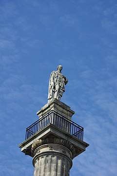 Grey's Monument in Newcastle City Centre, from which the electoral ward takes its name. | |
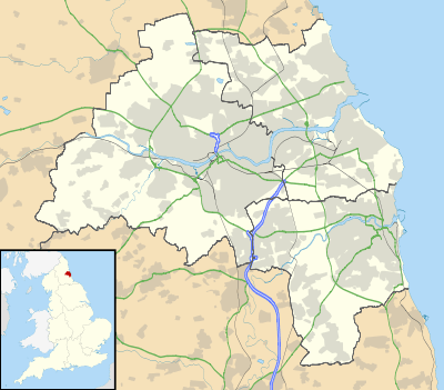 Monument ward, Newcastle upon Tyne Monument ward, Newcastle upon Tyne shown within Tyne and Wear | |
| OS grid reference | NZ248643 |
| • London | 275 mi (443 km) SSE |
| Metropolitan borough | |
| Metropolitan county | |
| Region | |
| Country | England |
| Sovereign state | United Kingdom |
| Post town | NEWCASTLE UPON TYNE |
| Postcode district | NE1 |
| Dialling code | 0191 |
| Police | Northumbria |
| Fire | Tyne and Wear |
| Ambulance | North East |
| EU Parliament | North East England |
| UK Parliament | |
| Councillors | |
Monument is an electoral ward of Newcastle upon Tyne in North East England. Created in 2018, the ward takes its name from Grey's Monument in Newcastle City Centre. It replaced most of Westgate ward and parts of South Jesmond and Ouseburn wards.
Overview
Monument ward is largely the city centre, including key features such as the Civic Centre, Northumbria University and Newcastle University campuses, the Royal Victoria Infirmary and St James’ Park football ground. It contains the city centre business, shopping, cultural and nightlife districts. Key transport links, including the Central Station and various Metro stations and bus stations are within this ward.
Education
There are no primary schools within the ward and only one secondary School (Discovery School), which is due to close in summer 2018. The ward is home to Newcastle College and Newcastle Sixth Form College and the city campuses of both Newcastle University and Northumbria University.
Recreation and leisure
Leazes Park is in the north-west of the ward. Facilities there include a bowling green, tennis courts and basketball courts, a fenced playground with swings, slides, climbing frames and spring toys.
The ward includes the city's main shopping, cultural and nightlife districts. Attractions include:
- Bigg Market
- Centre for Life
- Chinatown
- Discovery Museum
- Eldon Square Shopping Centre and Northumberland Street
- Grainger Town (including Grainger Market and Grey Street)
- Great North Museum: Hancock
- Newcastle City Hall
- Live Theatre
- the Quayside
- St James' Park (home of Newcastle United F.C.)
- Sport Central
- Theatre Royal
- The Gate
- Tyneside Cinema
- Tyne Theatre and Opera House
Transport
Newcastle's main railway station is in the south of the ward and there are six Metro stations: Haymarket and Central Station on the north-south route, St James and Manors on the east-west route, with both routes meeting st Monument Metro station.
Many local and regional buses serve Eldon Square or Haymarket bus stations, with most long-distance coaches serving Newcastle Coach Station.
Boundary
Monument ward is bounded by the River Tyne to the south. From the south-west corner, the boundary runs north joining William Armstrong Drive and then east on Scotswood Road and north again on to Park Road. It turns north-east on Westmorland Road, north-west on Rye Hill and north-east on Elswick Road, crossing the Westgate Road and continuing east on Corporation Street. Here the boundary heads northwards briefly on St James’ Boulevard and north-west on Barrack Road, turning north on the footpath through Leazes Park until it meets Richardson Road. The boundary heads north between the student accommodation and the Royal Victoria Infirmary, on to Claremont Street, crossing Claremont Road on to Jedburgh Road. Here the boundary heads south east on the A167/A167(M). Where the road crosses the B1307, the boundary turns off east, then south between the Army Reserves Centre and rear of Harrison Place and Gladstone Terrace. The boundary continues south on Byron Street, Falconar Street, Simpson Terrace, Argyle Street and Tower Street, where it crosses City Road and makes it way south to the Quayside and the River Tyne.
External links
Map of Monument ward, on the Newcastle City Council website.