Montoya, New Mexico
| Montoya, New Mexico | |
|---|---|
| Unincorporated community | |
_from_NW_1.JPG) Richardson store, 2015 | |
 Montoya, New Mexico | |
| Coordinates: 35°05′59″N 104°03′50″W / 35.09972°N 104.06389°WCoordinates: 35°05′59″N 104°03′50″W / 35.09972°N 104.06389°W | |
| Country | United States |
| State | New Mexico |
| County | Quay |
| Elevation | 4,321 ft (1,317 m) |
| Time zone | UTC-7 (Mountain (MST)) |
| • Summer (DST) | UTC-6 (MDT) |
| Area code(s) | 575 |
| GNIS feature ID | 915865[1] |
Montoya, New Mexico is an unincorporated community on the route of historic Route 66 in Quay County, New Mexico.[1] It is the site of the Richardson Store, listed on the National Register of Historic Places.[2]
References
- 1 2 "Montoya". Geographic Names Information System. United States Geological Survey.
- ↑ National Park Service (2010-07-09). "National Register Information System". National Register of Historic Places. National Park Service.
Municipalities and communities of Quay County, New Mexico, United States | ||
|---|---|---|
| City | 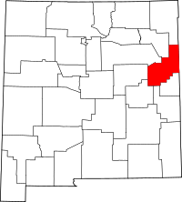 | |
| Villages | ||
| CDP | ||
| Other unincorporated communities | ||
| Footnotes | ‡This populated place also extends into Texas | |
This article is issued from
Wikipedia.
The text is licensed under Creative Commons - Attribution - Sharealike.
Additional terms may apply for the media files.