Montemonaco
| Montemonaco | ||
|---|---|---|
| Comune | ||
| Comune di Montemonaco | ||
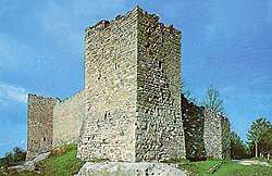 Torrioni on Montemonaco walls | ||
| ||
 Montemonaco Location of Montemonaco in Italy | ||
| Coordinates: 42°54′N 13°20′E / 42.900°N 13.333°ECoordinates: 42°54′N 13°20′E / 42.900°N 13.333°E | ||
| Country | Italy | |
| Region | Marche | |
| Province | Ascoli Piceno (AP) | |
| Frazioni | Altino, Ariconi, Cerqueto, Cese, Cittadella, Colleregnone, Collina, Ferrà, Foce, Isola San Biagio, Lanciatoio, Le Castagne, Le Vigne, Pescolle, Pignotti, Poggio di pietra, Rascio, Rivo Rosso, Rocca, Rocca da capo, Ropaga, San Giorgio all'Isola, San Lorenzo, Tofe, Vallefiume, Vallegrascia. | |
| Government | ||
| • Mayor | Onorato Corbelli | |
| Area | ||
| • Total | 67.52 km2 (26.07 sq mi) | |
| Elevation | 980 m (3,220 ft) | |
| Population (28 February 2010)[1] | ||
| • Total | 658 | |
| • Density | 9.7/km2 (25/sq mi) | |
| Demonym(s) | Montemonachesi | |
| Time zone | UTC+1 (CET) | |
| • Summer (DST) | UTC+2 (CEST) | |
| Postal code | 63048 | |
| Dialing code | 0736 | |
| Patron saint | St. Sebastian | |
| Saint day | January 20 | |
Montemonaco is a town and comune (municipality) in Marche region , located about 150 kilometres (93 mi) north-east from Rome. It is located within Sibillini Mountains, along Aso valley, on a plateau facing the Mount Zampa and Mount Sibilla. Nearby are located Mount Vector and the Pilatus Lake.
Slightly involved in recent earthquakes, Montemonaco ("MonkMount") takes its name from a Benedictine monastery founded here around the 8th century.
References

This article is issued from
Wikipedia.
The text is licensed under Creative Commons - Attribution - Sharealike.
Additional terms may apply for the media files.