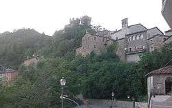
Arquata del Tronto
| Arquata del Tronto | ||
|---|---|---|
| Comune | ||
| Comune di Arquata del Tronto | ||
 | ||
| ||
 Arquata del Tronto Location of Arquata del Tronto in Italy | ||
| Coordinates: 42°46′21″N 13°17′47″E / 42.77250°N 13.29639°ECoordinates: 42°46′21″N 13°17′47″E / 42.77250°N 13.29639°E | ||
| Country | Italy | |
| Region | Marche | |
| Province | Ascoli Piceno (AP) | |
| Frazioni | Pretare, Trisungo, Piedilama, Borgo, Spelonga, Colle | |
| Government | ||
| • Mayor | Aleandro Petrucci | |
| Area | ||
| • Total | 92.23 km2 (35.61 sq mi) | |
| Elevation | 777 m (2,549 ft) | |
| Population (31 March 2017)[1] | ||
| • Total | 1,137 | |
| • Density | 12/km2 (32/sq mi) | |
| Demonym(s) | Arquatani | |
| Time zone | UTC+1 (CET) | |
| • Summer (DST) | UTC+2 (CEST) | |
| Postal code | 63043 | |
| Dialing code | 0736 | |
| Patron saint | St. Peter | |
| Saint day | 27 August | |
| Website | Official website | |

Arquata del Tronto is a comune (municipality) in Province of Ascoli Piceno in the Italian region Marche, located about 100 kilometres (62 mi) . It's the only european municipality located partly within two natural parks: Gran Sasso national park and Cyblings mountains natural park.
History
Ancient history of the town is uncertain, though some scholars have assigned it to Surpicanum visible in the Peutingerian Table, a centre of the Piceni or the Sabines whose location is however still debated. Another theory has it founded by the Romans as a road station on the Via Salaria.[2] The first mention of Arquata dates to the Middle Ages (6th century), when a stronghold existed here. In 1255 it was conquered by Ascoli Piceno, under which it remained (with a certain autonomy) until the late 14th century. In 1397, during the war between Ascoli and Norcia, it was a stronghold of the latter and the Ghibellines from Ascoli. Queen Joan II of Naples lived in Arquata from 1420 to 1435. After being contended for years between the two aforementioned cities, it was part of the Papal States; Giuseppe Garibaldi stopped here in 1849 during his retreat after the crushing of the Roman Republic in 1848.
On August 24, 2016, as much as two to three frazioni were damaged by a 6.2-magnitude earthquake.[3][4]
On October 30, 2016, the town suffered significant damage, and may have been completely destroyed, from a earthquake magnitude 6.6.[5][6]
Main sights
- The Rocca (castle), built in the 13th century, commanding the Via Salaria and the Tronto river.
- Sant'Agata Gate, the last remaining element of the medieval walls.
- Church of SS. Annunziata, housing a 16th-century Annunciation and a precious 13th century wooden crucifix, considered the oldest holy statue in the Marche.
- In the frazione of Pretare is an ancient furnace.
References
- ↑ All demographics and other statistics: Italian statistical institute Istat.
- ↑ Harris, W. "Places: 416863 (Surpicanum)". Pleiades. Retrieved October 30, 2016.
- ↑ "Powerful Earthquakes in Italy", The New York Times, 24 August 2016.
- ↑ "Italy earthquake: Death toll rises to at least 120, Prime Minister Matteo Renzi says", abc.net.au, 25 August 2016.
- ↑ "Terremoto, Arquata del Tronto non esiste più". Retrieved 30 October 2016.
- ↑ Salvo Sotille [@salvosottile] (30 October 2016). "Ecco come appare Arquata ora ,paura e distruzione #terremoto" (Tweet) (in Italian) – via Twitter.
External links
| Wikimedia Commons has media related to Arquata del Tronto. |
