Montagano
| Montagano | |
|---|---|
| Comune | |
| Comune di Montagano | |
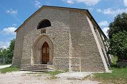 Abbey of Santa Maria di Faifoli. | |
 Montagano Location of Montagano in Italy | |
| Coordinates: 41°39′N 14°40′E / 41.650°N 14.667°ECoordinates: 41°39′N 14°40′E / 41.650°N 14.667°E | |
| Country | Italy |
| Region | Molise |
| Province | Campobasso (CB) |
| Government | |
| • Mayor | Giuseppantonio Mariano |
| Area | |
| • Total | 26.5 km2 (10.2 sq mi) |
| Elevation | 803 m (2,635 ft) |
| Population (31 May 2016)[1] | |
| • Total | 1,082 |
| • Density | 41/km2 (110/sq mi) |
| Demonym(s) | Montaganesi |
| Time zone | UTC+1 (CET) |
| • Summer (DST) | UTC+2 (CEST) |
| Postal code | 86023 |
| Dialing code | 0874 |
| Patron saint | Sant' Alessandro |
| Website | Official website |
Montagano is a comune (municipality) in the Province of Campobasso in the Italian region Molise, located about 9 kilometres (6 mi) north of Campobasso. Montagano rises on one side of the Biferno river, where once stood an ancient Samnite town where inhabitants in the 4th century B.C. sided with Hannibal against Rome.
Montagano is a beautiful and quaint, white stone village surrounded by farmland that borders the following municipalities: Limosano, Matrice, Petrella Tifernina, Ripalimosani.
References
External links

This article is issued from
Wikipedia.
The text is licensed under Creative Commons - Attribution - Sharealike.
Additional terms may apply for the media files.