Colletorto
| Colletorto | |
|---|---|
| Comune | |
| Comune di Colletorto | |
 | |
 Colletorto Location of Colletorto in Italy | |
| Coordinates: 41°40′N 14°58′E / 41.667°N 14.967°ECoordinates: 41°40′N 14°58′E / 41.667°N 14.967°E | |
| Country | Italy |
| Region | Molise |
| Province | Campobasso (CB) |
| Government | |
| • Mayor | Agnese Scala |
| Area | |
| • Total | 35.91 km2 (13.86 sq mi) |
| Elevation | 515 m (1,690 ft) |
| Population (30 November 207)[1] | |
| • Total | 1,872 |
| • Density | 52/km2 (140/sq mi) |
| Demonym(s) | Colletortesi |
| Time zone | UTC+1 (CET) |
| • Summer (DST) | UTC+2 (CEST) |
| Postal code | 86044 |
| Dialing code | 0874 |
| Patron saint | St. John the Baptist |
| Saint day | 29 August |
| Website | Official website |
Colletorto is a comune (municipality) in the Province of Campobasso in the Italian southern region of Molise, located about 45 kilometres (28 mi) from the capital of the region Campobasso and 40 kilometres (25 mi) from Termoli (CB) sea town with port, railway and highway A14 (Adriatic line).
Geography
Colletorto is situated on a hill 508 mt above sea level up to colle Crocella (776 m) in the Fortore river valley on the "Monti Frentani".
Near Colletorto is situated the Occhito lake, an artificial lake on the Fortore river that sign the limith with the Apulia region, the lake of Guardialfiera is 15 km away.
Other important river on the territory are the torrent of Santa Maria and the Cigno river both branches of the Fortore river.
The hills around Colletorto are divided in forest of oaks, mediterranean maquis, olive trees and fields of cereals and other agricultural products.
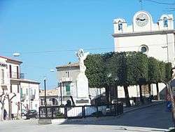
The town is divided in two parts: the upper part is called "Colle" (Hill) and the lower is named "Terra" with the main road and center "Corso Vittorio Emanuele", crossing the center there is the old town district "Campo dei Fiori" (Field of flowers) with the Parish church of Saint John the Baptist, the palace of marquis Rota (Local council domicile) and the Angioina tower, 25 m tall and built in 1369 by Queen Joanna I of Naples, with an amazing view from the terrace on the Gargano mountain (Apulia), the Lesina lake, the Adriatic Sea and the Tremiti Islands.
Colletorto borders the following municipalities: Carlantino, Casalnuovo Monterotaro, San Giuliano di Puglia, Sant'Elia a Pianisi.
Main sights
- Angevine Tower. Built in 1369 by Queen Joanna I of Naples, it is the main monument of Colletorto. Standing at 25 meters, it was built on an old Norman castle of whose old walls are still visible. Since 1959 it is a possession of the local council, donated by a private family and the last restoration was in 2012.
- Palazzo Rota (18th century), now the Town Hall
- Parish Church of Saint John the Baptist (1730)
- Monastery and Church of Saint Alfonso de' Liguori (1728)
- Church of Purgatory (1776), now deconsecrated
- Chapel of Our Lady of Loreto, situated on a hill 3 km away from Colletorto, surrounded by olive trees.
- Chapel of Saint Rocco, situated 2 km away from Colletorto, in the cemetery.
Economy
The economy of Colletorto is mainly based on agriculture, producing cereals and especially extra virgin olive oil of excellent quality.
The "Oliva nera di Colletorto" is a native tree of Colletorto and his oil is necessary to produce the "DOP Molise".
On the territory are present many oil mills, one paper factory and private workshops.
Under construction there is a health center for elderly persons.
Transport
Colletorto is connected by public bus to the nearest towns and the mains in the Province of Campobasso.
The closest train station is Bonefro-Santa Croce station 14 km away on the regional line Termoli–Venafro railway.
Twin towns