Montafon
Montafon (in local dialect: "Muntafu") is a 39 km long valley in the federal state of Vorarlberg (Austria) that is crossed by the river Ill (Vorarlberg). It extends from the city of Bludenz and the Verwall Alps in the north, to the Silvretta and Rätikon mountain range in the south. Piz Buin is with 3312m the highest peak within the Silvretta mountain range. The area has a population of 16.642 people. (January 1, 2016)
Geography

The Montafon is the association of ten villages.[1] All municipalities in the Montafon belong the Bludenz district, the main town is Schruns. The whole regions tourism is marketed by the Tourist association Montafon - an association of the municipalities, the Vorarlberger Illwerke and the regional Mountain railways.[2]
These municipalities are:
- Gaschurn (1000m)
- Sankt Gallenkirch (900m)
- Schruns (700 m)
- Tschagguns (700 m)
- Silbertal (890 m)
- Bartholomäberg (1100 m)
- Vandans (660 m)
- St. Anton im Montafon (650 m)
- Lorüns (583 m) und
- Stallehr (600 m)
Travelling from Bludenz, you enter state road B188 which takes you by the old cement plant of Lorüns and through the town of Lorüns. After driving through the Alma woods and past the Tränabächle (brook of tears) the valley opens to its main splendor at St. Anton (in the local dialect: "Santatöni") on the left, and Vens and Vandans on the right. St. Anton, which is not to be confused with its larger and more famous St. Anton am Arlberg, is the hometown of the Stemer clan and the Battlogg clan.
On the way to Rodund lays the main electrohydric plant of the Vorarlberger Illwerke, through Gantschier and Kaltenbrunnen and on to Schruns and Tschagguns (in the local dialect: "Schru und Tschaggu"). The mountain town of Bartholomäberg is situated above Schruns, with its outliers Jetzmunt and Lutt overlooking St. Anton as well as its southeastern outliers Kristberg and Innerberg overlooking the Silbertal valley. This valley stretches from Schruns to the outpost of the Fellamendli in a south-easterly direction pointing towards the Arlberg mountain range. The hamlet of Latschau, with its hydroelectric power station and the main base of the Golm ski resort, watches over Tschagguns opposite from Bartholomäberg.
From Schruns and Tschagguns onward you cross the Montafon midpoint that divides the outer valley ("Außerfratte") from the inner valley ("Innerfratte"). As you arrive in St. Gallenkirch, you will be able to branch off at Galgenul towards Gargellen, another magically rugged branch valley that finishes at the ski resort of Gargellen. Continuing in the main Montafon valley, you will pass through Gortipohl and on to Gaschurn (in the local dialect: "Gaschorra") and then Partenen, where the road starts to snake up to the Silvretta mountain pass.
Economy
The economy in Montafon consists of a mixture of traditional activities like forestry industry, energy-production due to the height-differences and its potential for Hydroelectricity, the production of agriculture products as well as tourism related services and products.
Agriculture and Farming
Farming and agriculture are part of the Alpine transhumance, a 3-phase cultivation and inclusion of all mountain levels. It is a seasonal droving of grazing livestock between the valleys in winter and the high mountain pastures in summer because food supply for the cattle varies throughout the year.[3] While tourism and other industries are higher contributor to the economy, seasonal migration to high pastures is still practiced today. In autumn, if no animal has died, the farmers decorate all the cattle and start to bring them down from the mountain pastures in one big procedure making it a highlight of regional culture.
Tourism
Tourism plays a vital role and the Montafon is famous for skiing, hiking, and mountain biking. A main road, the Silvretta high alpine road (German: Hochalpenstraße) gives access to the remote ski areas that are located on a sea-level between 650 and 1430m. The construction of the Montafon Railway in 1905 helped also into bringing around 2 million overnights to the region each year.[4]
There are 5 ski areas Golm, Silvretta Montafon, Gargellen, Silbertal-Kristberg and Silvretta-Bielerhöhe with 60 ski lifts and 225 km ski slopes in this area. Freeriding is a popular sport and various fun parks with half-pipes can be found there. For Cross-country skiing (sport) there are 121 km classic routes as well as 33 km skating-routes.
More and more popular is Ski mountaineering which can be done on every mountain in Montafon.[5]
During the summers, people can use the vast hiking trails along all the mountain ranges. There are even trails that can be accessed via pushchairs („Muntafuner Gagla Weg“). Nine of the ski lifts are also open during the summer season and allow quick ascends or descends of the mountains. All hiking and biking trails are marked very well and signs indicate rights and limitations. Many areas are protected and biking is not always allowed. Litering can be fined and all trash should be disposed of in the appropriate places at the starting or finishing point. 26 alpine huts are open during summer and special buses for hikers operate in the area.
Climbing can be done on various trails of different difficulties. For beginners, there are 8 climbing parks and 15 fixed rope routes.
There are also two 9-hole golf courses, one in Tschagguns and one in Partenen.[6]
Culture
A number of celebrities have stayed in the valley. Some of the older folks still talk about the long nights in Schruns playing cards and drinking with Ernest Hemingway and John dos Passos. The Snows of the Kilimanjaro and several other novels and short stories were written in, or they contain material from, the Montafon and the Silvretta glaciers. Later, the famous German novelist and poet Erich Kästner repeatedly visited the valley, as did the former German chancellor Helmut Kohl. The noted opera singer Elisabeth Schwarzkopf spent her last years in Schruns, where she died on August 2, 2006.
Alpine Culture
The LEADER programme Gauertaler Alpenkultur[7] has been created to inform guests and locals in the Gauertal valley about the cultural landscape. Knowing how this cultural landscape has emerged is slowly being lost. Therefore, this path was created as the Gauertal is a good example of the local alpine culture and alpine transhumance, a 3-phase cultivation and inclusion of all mountain levels. As the trails in the Gauertal are one of the most popular in Vorarlberg, another part of the project was to steer the hikers in such a way, that the sensitive alpine areas are no longer affected by the visitors' streams.
At 13 stations, objects were created by artists who devoted themselves to the areas of this culture. Panels and infobrochures tell the stories about the country, the people and the culture.
The following artistic intervention have been created in the Gauertaler landscape:
- Entrance gate
- Tree of Myths (Alpmyths)
- Note 1: Water & Alpe
- Watcher (shepherds life)
- Alpe & tourism (no sculpture)
- Note 2 (Forest Striving)
- Tribune (life in the Maisäß)
- Cloakroom (change of culture)
- Avalanche tree (natural hazards)
- Battlefield (History in the Alps)
- Alpinism (no sculpture)
- Cheese harp (life and work)
- Antler tree (alp and hunting)
There are 3 different paths and each tell a different story[8]:
- Main tour Gauertaler Alpkultur: Grüneck (1890m) - Obere Latschätzalpe - Obere Sporaalpe - Lindauer Hütte - untere Sporaalpe - untere Latschätzalpe - Wachters Dieja - Plazadels - Matschwitz Length: 12,7 km Duration: approx 4 Hours
- Alptour: Grüneck (1890m) - Obere Latschätzalpe - Obere Sporaalpe - Lindauer Hütte - untere Sporaalpe - untere Latschätzalpe - Gauen - Latschau Length: 11,3 km Duration: approx 3,5 Hours
- Maisäßtour (Tour of the alpine transhumance): Grüneck (1890m) - Obere Latschätzalpe - Wachters Dieja - Plazadels - Matschwitz Length: 6,7 km Duration: approx 2,5 Hours
Habits
The Alpine Transhumance plays a vital role to traditional Alpine culture like Yodel, Alphorn, Schwingen, and cheese production.
Montafon House
The Montafon House is a typical stone-wood house built in the Montafon from the 15th to the 20th century. It is the main component of the Montafon cultural landscape and is a characteristic of the valley.[9]
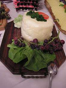
The Montafonese cheese (Montafoner Sauerkäse)
The "Montafoner Sauerkäse" or montafonese cheese (dialect: Sura Kees or Sura Käs stands for a type of sour cream/curdled milk cheese) is a sour cream cheese made in the Montafon since the 12th century. Montafon has one of the oldest traditions in cheese production in the Alpine region and is still an important dairy product. It has very little fat (1-10% fat in dry matter) and is a local speciality. It is similar to the tyrolean grey cheese.[10]
References
- ↑ "Die Geschichte des Standes Montafon — Stand Montafon". stand-montafon.at. Retrieved 2017-01-02.
- ↑ "Impressum: Montafon Tourismus GmbH". www.montafon.at. Retrieved 2017-01-02.
- ↑ "Österreichische UNESCO-Kommission - Nationalagentur für das Immaterielle Kulturerbe". unesco.scharf.net. Retrieved 2017-01-02.
- ↑ "State of Vorarlberg - Tourismus facts and figures". www.vorarlberg.at. Retrieved 2017-01-02.
- ↑ "Skitouren Vorarlberg : Wintersport im Montafon, Alpen". www.montafon.at. Retrieved 2017-01-02.
- ↑ "Activities in the Montafon - Montafon Austria". www.montafon.at. Retrieved 2017-01-02.
- ↑ Vorarlberg, Kunstforum Montafon. "AlpkulTour Kunstforum Montafon Vorarlberg Österreich". www.kfm.at. Retrieved 2017-02-24.
- ↑ Betriebsges.m.b.H., Illwerke Seilbahn. "Gauertaler AlpkulTour - on the culture trail". Golm im Montafon. Retrieved 2017-02-24.
- ↑ Josef., Zurkirchen, (1988-01-01). Heimatbuch St. Gallenkirch, Gortipohl, Gargellen. Gemeinde St. Gallenkirch. ISBN 3854301014. OCLC 74955669.
- ↑ "Montafoner Sura Kees". www.genuss-region.at. Retrieved 2017-01-02.