Mont Shefford
| Mont Shefford | |
|---|---|
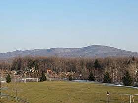 Mont Shefford seen from Terry Fox Park in Granby | |
| Highest point | |
| Elevation | 526 m (1,726 ft) |
| Coordinates | 45°21′49″N 72°37′33″W / 45.36361°N 72.62583°WCoordinates: 45°21′49″N 72°37′33″W / 45.36361°N 72.62583°W |
| Geography | |
 Mont Shefford Shefford, 12 kilometers southeast of Granby, Quebec, Canada | |
| Parent range | Monteregian Hills |
| Topo map | NTS 031H/07 |
| Geology | |
| Age of rock | Early Cretaceous |
| Mountain type | Intrusive stock |
Mont Shefford is a Monteregian Hill located in Shefford in the Montérégie region of Quebec, Canada.
Mont Shefford is 526 metres (1,726 ft) tall, and was home to the Ski Shefford ski resort which closed in 2006.
Geology
Mount Shefford was formed some 125 million years ago during an underground intrusion of magma. This magma did not reach the earth's surface and remained in a deep freeze. The mountain appeared following the erosion of nearby sedimentary rocks by glaciers. The sedimentary rock was more fragile than the metamorphic rock formed by the contact of the magma and the surrounding sedimentary rock.
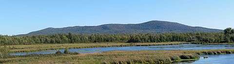
Mont Shefford seen from Lac Boivin in Granby.
This article is issued from
Wikipedia.
The text is licensed under Creative Commons - Attribution - Sharealike.
Additional terms may apply for the media files.