Monroe Township, Preble County, Ohio
| Monroe Township, Preble County, Ohio | |
|---|---|
| Township | |
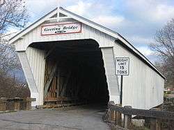 Geeting Covered Bridge, a historic site in the township | |
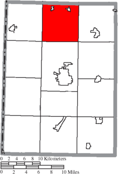 Location of Monroe Township in Preble County | |
| Coordinates: 39°53′5″N 84°39′27″W / 39.88472°N 84.65750°WCoordinates: 39°53′5″N 84°39′27″W / 39.88472°N 84.65750°W | |
| Country | United States |
| State | Ohio |
| County | Preble |
| Area | |
| • Total | 35.2 sq mi (91.2 km2) |
| • Land | 35.2 sq mi (91.2 km2) |
| • Water | 0.0 sq mi (0.0 km2) |
| Elevation[1] | 1,109 ft (338 m) |
| Population (2000) | |
| • Total | 2,290 |
| • Density | 65.0/sq mi (25.1/km2) |
| Time zone | UTC-5 (Eastern (EST)) |
| • Summer (DST) | UTC-4 (EDT) |
| FIPS code | 39-51548[2] |
| GNIS feature ID | 1086853[1] |
Monroe Township is one of the twelve townships of Preble County, Ohio, United States. The 2000 census found 2,290 people in the township, 1,314 of whom lived in the unincorporated portions of the township. The Monroe community is served by National Trail High School and the National Trail Local School District. Interstate 70 runs along the southern part of the township and has a major interchange at U.S. Route 127. [3]
Geography
Located in the northern part of the county, it borders the following townships:
- Butler Township, Darke County - north
- Twin Township, Darke County - northeast corner
- Harrison Township - east
- Twin Township - southeast corner
- Washington Township - south
- Jackson Township - southwest corner
- Jefferson Township - west
- Harrison Township, Darke County - northwest corner
Two incorporated villages are located in Monroe Township: Eldorado in the northwest, and West Manchester in the northeast. Two major U.S highways intersect within the township. U.S. Route 40 runs east and west, while U.S. Route 127 runs north and south.
Name and history
Monroe Township was established in 1817.[4] It is one of twenty-two Monroe Townships statewide.[5]
Government
The township is governed by a three-member board of trustees, who are elected in November of odd-numbered years to a four-year term beginning on the following January 1. Two are elected in the year after the presidential election and one is elected in the year before it. There is also an elected township fiscal officer,[6] who serves a four-year term beginning on April 1 of the year after the election, which is held in November of the year before the presidential election. Vacancies in the fiscal officership or on the board of trustees are filled by the remaining trustees.
References
- 1 2 "US Board on Geographic Names". United States Geological Survey. 2007-10-25. Retrieved 2008-01-31.
- ↑ "American FactFinder". United States Census Bureau. Retrieved 2008-01-31.
- ↑ Preble County, Ohio — Population by Places Estimates Ohio State University, 2007. Accessed 15 May 2007.
- ↑ History of Preble County, Ohio, with illustrations and biographical sketches. H. Z. Williams & Bro. 1881. p. 289.
- ↑ "Detailed map of Ohio" (PDF). United States Census Bureau. 2000. Retrieved 2007-02-16.
- ↑ §503.24, §505.01, and §507.01 of the Ohio Revised Code. Accessed 4/30/2009.
External links
Municipalities and communities of Preble County, Ohio, United States | ||
|---|---|---|
| City | 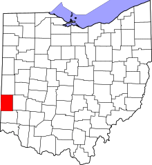 | |
| Villages | ||
| Townships | ||
| CDP | ||
| Unincorporated communities | ||
| Ghost towns | ||
| Footnotes | ‡This populated place also has portions in an adjacent county or counties | |