Mohawk, Oregon
| Mohawk | |
|---|---|
| Unincorporated community | |
.jpg) | |
 Mohawk Location within the state of Oregon  Mohawk Mohawk (the US) | |
| Coordinates: 44°8′32″N 122°54′58″W / 44.14222°N 122.91611°WCoordinates: 44°8′32″N 122°54′58″W / 44.14222°N 122.91611°W | |
| Country | United States |
| State | Oregon |
| County | Lane |
| Time zone | UTC-8 (Pacific (PST)) |
| • Summer (DST) | UTC-7 (PDT) |
| ZIP code | 97478 |
| Area code(s) | 458 and 541 |
| GNIS feature ID | 1167030 |
Mohawk is an unincorporated community in Lane County, Oregon, United States, on the Mohawk River, about seven miles upstream from Springfield.[1]
When a post office was established at this locale in 1862, it was named "Mohawk" after the river.[1] The post office operated intermittently, and after being converted to a rural station in 1958, it was finally terminated in 1961.[1] When the Southern Pacific Railroad established a station on the Marcola line there, it was named "Donna".[1][2] Historically there was also a nearby locale known as "Mohawk Post".[3]
References
- 1 2 3 4 McArthur, Lewis A.; Lewis L. McArthur (2003) [1928]. Oregon Geographic Names (7th ed.). Portland, Oregon: Oregon Historical Society Press. p. 654. ISBN 0-87595-277-1.
- ↑ U.S. Geological Survey Geographic Names Information System: Donna (historical)
- ↑ U.S. Geological Survey Geographic Names Information System: Mohawk Post (historical)
External links
- Historic image of covered railroad bridge near Mohawk from Salem Public Library
- 1954 image of Wegner House in Mohawk from the University of Oregon Library collections
Municipalities and communities of Lane County, Oregon, United States | ||
|---|---|---|
| Cities | 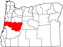 | |
| Unincorporated communities |
| |
| Ghost towns | ||
| Indian reservation | ||
| Footnotes | ‡This populated place also has portions in an adjacent county or counties | |
This article is issued from
Wikipedia.
The text is licensed under Creative Commons - Attribution - Sharealike.
Additional terms may apply for the media files.