Deadwood, Oregon
| Deadwood | |
|---|---|
| Unincorporated community | |
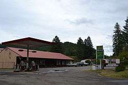 Store and gas station in Deadwood | |
 Deadwood Location within the state of Oregon  Deadwood Deadwood (the US) | |
| Coordinates: 44°5′45″N 123°45′44″W / 44.09583°N 123.76222°WCoordinates: 44°5′45″N 123°45′44″W / 44.09583°N 123.76222°W | |
| Country | United States |
| State | Oregon |
| County | Lane |
| Time zone | UTC-8 (Pacific (PST)) |
| • Summer (DST) | UTC-7 (PDT) |
Deadwood is an unincorporated community in Lane County, Oregon, United States. It is located on Oregon Route 36, in the Oregon Coast Range.
Deadwood was named after Deadwood Creek, a tributary of Lake Creek in the Siuslaw River basin. Deadwood Creek was so-named because of the dead timber snags next to its banks, which had resulted from a series of wildfires in the area.[1] Deadwood post office was established in 1884.[1] The post office was discontinued to the community of Greenleaf in 1914, but was reestablished in 1950.[1]
Deadwood is the home of Alpha Farm, an intentional community established in 1971.[2][3] The farm owns the Alpha Bit, a café and book/gift store in Mapleton.[2] Other residents include the artists Ernie and Mary Lou Goertzen who lived in the old Deadwood schoolhouse from 1975.[4]
References
- 1 2 3 McArthur, Lewis A.; McArthur, Lewis L. (2003) [1928]. Oregon Geographic Names (7th ed.). Portland, Oregon: Oregon Historical Society Press. ISBN 978-0875952772.
- 1 2 Alpha Farm (official website)
- ↑ Gatton, Dee Dee (May 1, 2014). "Alpha Farm: 'There are only two rules: no guns, no hard drugs'". KVAL-TV. Retrieved May 2, 2014.
- ↑ "Ernest "Ernie" Goertzen". Mennonite Weekly Review. September 2004. Retrieved May 2, 2014.
Municipalities and communities of Lane County, Oregon, United States | ||
|---|---|---|
| Cities | 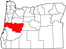 | |
| Unincorporated communities |
| |
| Ghost towns | ||
| Indian reservation | ||
| Footnotes | ‡This populated place also has portions in an adjacent county or counties | |