Mississippi Canyon

The Mississippi Canyon is an undersea canyon, part of the Mississippi Submarine Valley in the North-central Gulf of Mexico, south of Louisiana.[1] According to the U.S. Geological Survey GLORIA Mapping Program, it is the dominant feature of the north-central Gulf of Mexico. According to GCAGS Transactions, it has an average width of 8 kilometres (5.0 mi), and a length of 120 kilometres (75 mi). The US Minerals Management Service (MMS) applies the name Mississippi Canyon to numbered federal oil and gas lease blocks over a large offshore area centered on, but mostly outside, the submarine canyon.
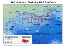
Oil and gas exploration and production
According to "Deepwater Gulf of Mexico 2004: America's Expanding Frontier", a report issued by the Minerals Management Service (MMS) Gulf of Mexico OCS Region, of the ten deepwater discoveries in water depths greater than 7,000 ft (2,134 m), three were in the Mississippi Canyon area: Aconcagua project, area/block MC305, 7,379 ft (2,249 m) deep; and Camden Hills project, MC348, 7,530 ft (2,300 m) deep, both discovered in 1999; and Blind Faith project, MC696, 7,116 ft (2,169 m) deep, discovered in 2001.[2] In a separate section of the same report, note is made of acreage in the Thunder Horse project, MC778, acquired in 1988. Other projects noted for Mississippi Canyon include Thunder Horse areas/blocks MC775-778 and MC819-822, listed as completed grid PEA (programmatic environmental assessment) by BP.[3]
An MMS list of 80 development systems of productive deepwater Gulf of Mexico projects from 1979 to 2003 includes 29 projects in the Mississippi Canyon area:[4]
| Year of 1st Production |
Project Name | Operator | Block | Water Depth ft. |
System Type |
|---|---|---|---|---|---|
| 1979 | Cognac | Shell | MC194 | 1,023 | Fixed Platform |
| 1984 | Lena | ExxonMobil | MC280 | 1,000 | Compliant Tower |
| 1991 | Amberjack | BP | MC109 | 1,100 | Fixed Platform |
| 1992 | Alabaster | ExxonMobil | MC485 | 1,438 | Subsea |
| 1993 | Diamond | Kerr McGee | MC445 | 2,095 | Subsea |
| 1993 | Zink | ExxonMobil | MC354 | 1,478 | Subsea |
| 1996 | Mars | Shell | MC807 | 2,933 | TLP/Subsea |
| 1997 | Mensa | Shell | MC731 | 5,318 | Subsea |
| 1999 | Gemini | ChevronTexaco | MC292 | 3,393 | Subsea |
| 1999 | Pluto | Mariner | MC674 | 2,828 | Subsea |
| 1999 | Ursa | Shell | MC809 | 1,478 | TLP |
| 2000 | Europa | Shell | MC935 | 3,870 | Subsea |
| 2000 | King | Shell | MC764 | 3,250 | Subsea |
| 2001 | Crosby | Shell | MC899 | 4,440 | Subsea |
| 2001 | MC68 | Walter | MC68 | 1,360 | Subsea |
| 2001 | Mica | ExxonMobil | MC211 | 4,580 | Subsea |
| 2002 | Aconcagua | TotalFinaElf | MC305 | 7,100 | Subsea |
| 2002 | Camden Hills | Marathon | MC348 | 7,216 | Subsea |
| 2002 | Horn Mountain | BP | MC127 | 5,400 | Spar |
| 2002 | King | BP | MC84 | 5,000 | Subsea |
| 2002 | Princess | Shell | MC765 | 3,600 | Subsea |
| 2003 | East Anstey/Na Kika | Shell | MC607 | 6,590 | FPS/Subsea |
| 2003 | Fourier/Na Kika | Shell | MC522 | 6,950 | FPS/Subsea |
| 2003 | Goose | Statoil | MC751 | 1,624 | Subsea |
| 2003 | Herschel/Na Kika | Shell | MC520 | 6,739 | FPS/Subsea |
| 2003 | Matterhorn | TotalFinaElf | MC243 | 2,850 | TLP |
| 2003 | Medusa | Murphy | MC582 | 2,223 | Spar |
| 2003 | Pardner | Anadarko | MC401 | 1,139 | Subsea |
| 2003 | Zia | Devon | MC496 | 1,804 | Subsea |
Five of the top 20 deepwater Gulf of Mexico production blocks for 2000-01 were in the Mississippi Canyon, including the top 2: Project Mars, 2,933 feet (894 m) deep, 137 million barrels (21.8×10⁶ m3) of oil equivalent (BOE); project Ursa, 3,800 feet (1,200 m) deep, 93 million barrels (14.8×10⁶ m3) of BOE; project Mensa, 5,280 feet (1,610 m), 27 million barrels (4.3×10⁶ m3) of BOE; Cognac, 1,023 feet (312 m), 23 million barrels (3.7×10⁶ m3) of BOE; Crosby, 4,259 feet (1,298 m), 18 million barrels (2.9×10⁶ m3) of BOE, all managed by Shell.[5]
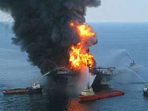
Deepwater Horizon explosion
On April 20, 2010, the Deepwater Horizon drilling rig, located in the MMS Mississippi Canyon block 252, which is about 40 miles (64 km) off the Louisiana coast, suffered a catastrophic explosion; it sank a day-and-a-half later.[6] Although initial reports indicated that relatively little oil had leaked, by April 27 it was stated by BP that approximately 5,000 barrels (790 m3) of oil per day were issuing from the wellhead, 1-mile (1.6 km) below the surface on the ocean floor.[7] The resulting oil slick quickly expanded to cover hundreds of square miles of ocean surface, posing a threat to marine life and adjacent coastal wetlands.[8] On June 10, the Flow Rate Group from the Deepwater Horizon Incident Joint Information Center reported that they have determined that the estimated flow rate from the out of control well head has been 20,000 barrels (3,200 m3) to 40,000 barrels (6,400 m3) per day.[9]
See also
References
- ↑ Geographic.org. "Mississippi Submarine Valley: Undersea Features (Full name, Geographic coordinates, map)". Geographical Names. Retrieved 2012-10-26.
- ↑ "List of Deepwater Discoveries in Water Depths Greater than 7,000 ft (2,134 m) in Deepwater Gulf of Mexico - America's Expanding Frontier". Retrieved 2010-07-28. .
- ↑ "Completed Grid PEA's Within the Central and Western Planning Areas of the Gulf of Mexico in Deepwater Gulf of Mexico - America's Expanding Frontier". Retrieved 2010-07-28. .
- ↑ "Development Systems of Productive Deepwater GOM Projects in Deepwater Gulf of Mexico - America's Expanding Frontier". Retrieved 2010-07-28.
- ↑ "Top 20 Producing Blocks for the Years 2001—2002 in Deepwater Gulf of Mexico - America's Expanding Frontier". Retrieved 2010-07-28. .
- ↑ "Burning oil rig sinks, setting stage for spill; 11 still missing", by Kevin McGill and Holbrook Mohr (Associated Press), Boston Globe, April 23, 2010
- ↑ "Well from sunken rig leaking oil", by Cain Burdeau (Associated Press), Boston Globe, April 25, 2010
- ↑ "Race to plug leaking oil well off La. spurs new tactics", by Cain Burdeau (Associated Press), Boston Globe, April 27, 2010
- ↑ http://www.deepwaterhorizonresponse.com/go/doc/2931/627011/
External links
- Gulf of Mexico GLORIA geology interpretation Page Contact Information: O'Malley, J., usgs.gov
- Formation of the Mississippi Canyon, GCAGS Transactions, Volume 32 (1982) (from Abstract) Coleman, J. M., D. B. Prior.
- Wonders of ocean life counted in massive census
Places adjacent to Mississippi Canyon | ||||||||||
|---|---|---|---|---|---|---|---|---|---|---|
| ||||||||||