Mission Township, Brown County, Kansas
| Mission Township | |
|---|---|
| Township | |
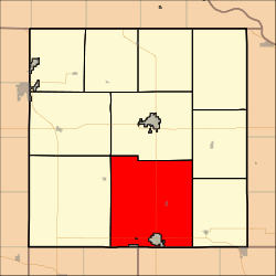 Location in Brown County | |
| Coordinates: 39°42′46″N 095°33′06″W / 39.71278°N 95.55167°WCoordinates: 39°42′46″N 095°33′06″W / 39.71278°N 95.55167°W | |
| Country | United States |
| State | Kansas |
| County | Brown |
| Area | |
| • Total | 85.08 sq mi (220.36 km2) |
| • Land | 84.46 sq mi (218.75 km2) |
| • Water | 0.62 sq mi (1.61 km2) 0.73% |
| Elevation | 1,115 ft (340 m) |
| Population (2000) | |
| • Total | 645 |
| • Density | 7.6/sq mi (2.9/km2) |
| GNIS feature ID | 0472980 |
Mission Township is a township in Brown County, Kansas, USA. As of the 2000 census, its population was 645.
Mission Township was formed in 1872.[1]
Geography
Mission Township covers an area of 85.08 square miles (220.4 km2). It contains one incorporated settlement, Willis, and surrounds another, the governmentally independent city of Horton. According to the USGS, it contains four cemeteries: Carr, Claytonville, Kennekuk and Saint Peters.
The stream of Hazel Creek runs through this township.
Transportation
Mission Township contains one airport or landing strip, Horton Municipal Airport.
References
External links
Municipalities and communities of Brown County, Kansas, United States | ||
|---|---|---|
| Cities | 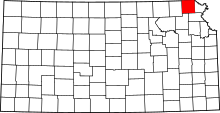 | |
| CDPs | ||
| Unincorporated communities | ||
| Indian reservations | ||
| Townships | ||
| Footnotes | ‡This populated place also has portions in an adjacent county or counties | |
This article is issued from
Wikipedia.
The text is licensed under Creative Commons - Attribution - Sharealike.
Additional terms may apply for the media files.