Miranjani
| Miranjani | |
|---|---|
 Miranjani from Nathiagali | |
| Highest point | |
| Elevation | 2,992 m (9,816 ft) |
| Coordinates | 34°06′30″N 73°24′20″E / 34.10833°N 73.40556°E [1] |
| Geography | |
| Location | Abbottabad District, Pakistan |
| Parent range | Himalayas |
| Climbing | |
| Easiest route | Hiking trails |
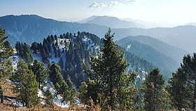
Miranjani is the highest peak, at 2,992 metres (9,816 ft) in elevation, of Abbottabad District in the Khyber Pakhtunkhwa Province of Pakistan. It is located in the Namli Maira area, in Ayubia National Park, 80 kilometres (50 mi) north of Islamabad in the western Himalayan range.
Trek
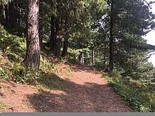
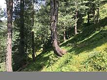
The Miranjani trek starts a few minutes drive away from the Governor House in Nathia Gali. The total length of the track is about 4.69 km and a net elevation of about 600 meters. Most of the path is soft dirt sparse with small rocks patches and hence is very easy to traverse with little effort. Intermediate to expert trekkers should be able to do it in 1 hour 15 mins to 2 hours. Beginners should also have no trouble and would be able to complete in 2-3 hours. The path to the peak is canopied with tall trees and is abundant in greenery.
Nathia Gali, Mushkpuri Peak and Azad Kashmir are easily visible from the top. On a clear day even Nanga Parbat, the ninth highest mountain in the world, at a displacement of 166 km or a distance of more than 400 km can be seen shining with its snow clad peaks.
If you carry further on from Miranjani one will reach Dagri Bangla and eventually Thandiani near Abbottabad.
See also
- Galyat - of Pakistan
- List of mountains in Pakistan
References
- ↑ Fallng Rain - Location of Miranjani Archived 2008-06-27 at the Wayback Machine.
External links
Coordinates: 34°06′30″N 73°24′20″E / 34.10833°N 73.40556°E