Milecastle 3
| Milecastle 3 | |
|---|---|
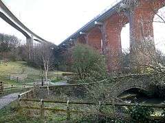 Milecastle 3 probably overlooked the Ouseburn ravine | |
 Milecastle 3 | |
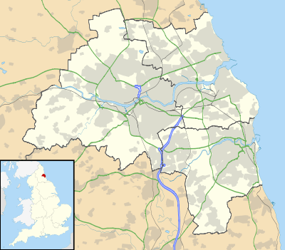
| OS grid reference | NZ26406466 |
| Coordinates | 54°58′33″N 1°35′20″W / 54.975901°N 1.589009°WCoordinates: 54°58′33″N 1°35′20″W / 54.975901°N 1.589009°W |
| |
 |
| Part of a series on the |
| Military of ancient Rome |
|---|
|
|
Milecastle 3 (Ouseburn) was a milecastle of the Roman Hadrian's Wall. No remains exist, but it was thought to have been located at the junction of the A187 Byker Bridge and Stephen Street.
Construction
No evidence exists as to the configuration or type of Milecastle 3, though the curtain wall at this stage was almost certainly a narrow configuration.[1]
Excavations and investigations
- 1789 - Brand visited the site, but noted that many of the stones had been removed from the foundations some years previously, for use in the building of an adjoining house.[4]
- 1848 - Collingwood Briuce reported that a small, partly illegible altar had been found close to the presumed site of the milecastle. The altar (NMR Number: NZ 26 SE 227) was dedicated by Julius Maximus. Having searched the area, he could find no trace of Roman remains.[1]
- 1858 - Henry MacLauchlan surveyed the area but reported no dependable trace of the milecastle.[5]
- 1928 - FG Simpson measured the distance from Milecastle 2 to Milecastle 3 as 1,450 yards (1,330 m).[5]
- 1979 - Exploratory trenches were sunk during the building of the Metro, revealing no trace of the milecastle.[5]
Associated Turrets
Each milecastle on Hadrian's Wall had two associated turret structures. These turrets were positioned approximately one-third and two-thirds of a Roman mile to the west of the Milecastle, and would probably have been manned by part of the milecastle's garrison. The turrets associated with Milecastle 3 are known as Turret 3A and Turret 3B.
Turret 3A
Nothing is known of Turret 3A.[6]
Presumed location: 54°58′30″N 1°35′46″W / 54.974892°N 1.596128°W
Turret 3B
Nothing is known of Turret 3B.[7]
Presumed location: 54°58′20″N 1°36′09″W / 54.972217°N 1.602403°W
Monument Records
| Monument | Monument Number | English Heritage Archive Number |
| Milecastle 3 | 24904 | NZ 26 SE 15 |
| Turret 3A | 24907 | NZ 26 SE 16 |
| Turret 3B | 24912 | NZ 26 SE 17 |
References
- 1 2 Breeze, David J (1934), Handbook to the Roman Wall (14th Revised edition - Nov 2006), Society of Antiquaries of Newcastle upon Tyne, ISBN 0-901082-65-1
- ↑ Horsley, John (1732), Britannia Romana or the Roman Antiquities of Britain, Frank Graham (published 1974), ISBN 0-85983-090-X
- ↑ Stukeley, William (1776). Itinerarium Curiosum: or, An account of the antiquities, and remarkable curiosities in nature or art, observed in travels through Great Britain (2nd ed.). London: Baker & Leigh. ISBN 0-576-19312-7.
- ↑ Brand, John (1 Jan 1789). The History and Antiquities of Newcastle upon Tyne. Vol 1 (1st ed.). B White & Son. p. 138.
- 1 2 3 "Milecastle 3". Pastscape. English Heritage. Archived from the original on 25 February 2012. Retrieved 24 May 2010.
- ↑ "Turret 3A". Pastscape. English Heritage. Archived from the original on 25 February 2012. Retrieved 24 May 2010.
- ↑ "Turret 3B". Pastscape. English Heritage. Archived from the original on 25 February 2012. Retrieved 24 May 2010.
Bibliography
- Daniels, Charles (1979), "Review: Fact and Theory on Hadrian's Wall", Britannia, 10: 357–364, JSTOR 526069
Structures of Hadrian's Wall | ||
|---|---|---|
| Milecastles |  | |
| Milefortlets | ||
| Other structures on Hadrian's Wall | ||
| Regular and linear features | ||