Milan metropolitan area
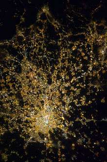
The Milan metropolitan area, also known as Grande Milano ("Greater Milan"), is the largest metropolitan area in Italy and the 54th largest in the world. The metropolitan area descripted in this article is strictly statistical and, contrary to the administrative Metropolitan City of Milan, a provincial-level municipality, does not imply any kind of administrative unity or function.
Definition
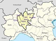
Given the absence of an official statistical definition for the metropolitan area of Milan, tracing precise boundaries is a somehow slippery issue. However, during the last decade, a number of studies have been carried out on the subject by some authoritative institutions and scholars, notably the Organisation for Economic Co-operation and Development and numerous Italian sources that build a definition based on commuting fluxes and on the concentration of commercial, leisure and public utility services. A broad consensus exists upon a definition that includes the central Lombard provinces of Milan, Bergamo, Como, Lecco, Lodi, Monza and Brianza, Pavia, Varese and the Piedmontese Province of Novara, while some scholars include also the Province of Cremona and Brescia in Lombardy and the Emilian Province of Piacenza. The overall population under the narrowest definition is about 8.2 million over an area of about 13,000 km2 (5,000 sq mi).[1][2][3][4]
| Provinces in the Milan metro area | Area (km2) |
2001 Population[5] |
2011 Population[5] |
2017 Population[6] |
% change (2011 to 2017) |
|---|---|---|---|---|---|
| Milan | 1,575.65 | 2,938,556 | 3,038,420 | 3,218,201 | +5.92% |
| Bergamo | 2,745.94 | 973,559 | 1,086,277 | 1,109,933 | +2.18% |
| Varese | 1,198.11 | 812,934 | 871,886 | 890,043 | +2.08% |
| Monza | 405.41 | 766,767 | 840,129 | 868,859 | +3.42% |
| Como | 1,279.04 | 537,853 | 586,735 | 600,190 | +2.29% |
| Pavia | 2,968.64 | 493,829 | 535,822 | 547,251 | +2.13% |
| Novara | 1,340.28 | 343,097 | 365,559 | 370,143 | +1.25% |
| Lecco | 814.58 | 311,637 | 336,310 | 339,238 | +0.87% |
| Lodi | 782.99 | 198,020 | 223,755 | 229,338 | +2.50% |
| Total | 13,110.64 | 7,376,242 | 7,884,893 | 8,173,176 | +3.66% |
Largest cities


The following is a list of the twenty largest cities in the Milan metropolitan area as ranked by population.
| Rank | City | Province | 2001 population[5] |
2011 population[5] |
2017 population[6] |
% change (2011 to 2017) |
|---|---|---|---|---|---|---|
| 1 | Milan | Milan | 1,256,211 | 1,242,123 | 1,351,562 | +8.81% |
| 2 | Monza | Monza | 120,104 | 119,856 | 122,955 | +2.59% |
| 3 | Bergamo | Bergamo | 112,864 | 115,349 | 120,287 | +4.28% |
| 4 | Novara | Novara | 100,939 | 101,952 | 104,165 | +2.17% |
| 5 | Como | Como | 78,546 | 82,045 | 84,326 | +2.78% |
| 6 | Busto Arsizio | Varese | 75,866 | 79,692 | 83,340 | +4.58% |
| 7 | Sesto San Giovanni | Milan | 78,831 | 76,514 | 81,822 | +6.94% |
| 8 | Varese | Varese | 80,492 | 79,793 | 80,694 | +1.13% |
| 9 | Cinisello Balsamo | Milan | 71,924 | 71,128 | 75,659 | +6.37% |
| 10 | Pavia | Pavia | 71,366 | 68,280 | 72,612 | +6.34% |
| 11 | Vigevano | Pavia | 57,444 | 60,109 | 63,505 | +5.65% |
| 12 | Legnano | Milan | 53,809 | 57,647 | 60,259 | +4.53% |
| 13 | Gallarate | Varese | 46,461 | 50,456 | 53,145 | +5.33% |
| 14 | Rho | Milan | 50,451 | 50,052 | 50,767 | +1.43% |
| 15 | Lecco | Lecco | 45,513 | 46,705 | 48,131 | +3.05% |
| 16 | Cologno Monzese | Milan | 48,270 | 45,786 | 47,751 | +4.29% |
| 17 | Paderno Dugnano | Milan | 45,439 | 46,562 | 46,590 | +0.06% |
| 18 | Lodi | Lodi | 40,894 | 43,332 | 45,212 | +4.34% |
| 19 | Lissone | Monza | 34,482 | 42,220 | 45,233 | +7.14% |
| 20 | Seregno | Monza | 39,171 | 43,001 | 44,962 | +4.56% |
See also
References
- ↑ "OECD Territorial Reviews: Milan, Italy" (PDF). OECD. Retrieved 13 October 2017.
- ↑ Campagna, Michele; et al. (2012). Planning Support Tools: Policy Analysis, Implementation and Evaluation. Proceedings of the Seventh International Conference on Informatics and Urban and Regional Planning INPUT2012. Milan: FrancoAngeli. pp. 1853–1856. ISBN 9788856875973.
- ↑ "Osservatorio sulla città metropolitana di Milano. Rapporto 2016" (PDF). Polytechnic University of Milan. Retrieved 13 October 2017.
- ↑ Salet, Willem; Thornley, Andy; Kreukels, Anton (2003). Metropolitan governance and spatial planning : comparative case studies of European city-regions. New York: Spon Press. p. 265. ISBN 978-0415274494.
- 1 2 3 4 "Historical population, 1861-2014". Istat. Retrieved 14 October 2017.
- 1 2 "Demographic balance, January-February 2017". Istat. Retrieved 14 October 2017.