List of neighbourhoods in Ottawa

Map showing Ottawa's central neighbourhoods
This is a list of neighbourhoods and outlying communities within the City of Ottawa, Ontario, Canada.
In 2001, the old city of Ottawa was amalgamated with the suburbs of Nepean, Kanata, Gloucester, Rockcliffe Park, Vanier and Cumberland, and the rural townships of West Carleton, Osgoode, Rideau and Goulbourn, along with the systems and infrastructure of the Regional Municipality of Ottawa-Carleton, to become one municipality. The city is now organized into 23 wards.
Old City of Ottawa
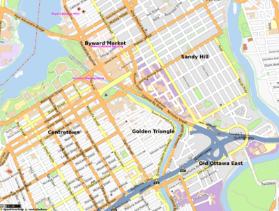
Map of the east end of Downtown Ottawa
Central Ottawa
East end
- Castle Heights
- Robillard Quarries
- Quarries
- Forbes
- Lees Avenue
- Lindenlea
- Manor Park
- New Edinburgh
- Overbrook
- Rockcliffe Park
- Vanier
- Viscount Alexander Park
South end
- Airport-Uplands
- Alta Vista
- Billings Bridge
- Confederation Heights
- Ellwood
- Elmvale Acres
- Greenboro
- Hawthorne Meadows
- Heron Gate
- Heron Park
- Hunt Club
- Hunt Club Chase
- Hunt Club Estate
- Hunt Club Park
- Riverside Park
- Riverside South
- Riverview
- Hunt Club Woods
- Mooney's Bay Park
- Sheffield Glen
- South Keys
West end
- Ambleside
- Bel-Air Heights|
- Bel-Air Park
- Braemar Park
- Britannia
- Britannia Bay
- Britannia Heights
- Carlington
- Civic Hospital
- Carleton Heights
- Central Park
- Copeland Park
- Courtland Park
- Glabar Park
- Hampton Park
- Highland Park
- Hintonburg
- Kenson Park
- Island Park
- McKellar Heights
- McKellar Park
- Mechanicsville
- Lincoln Heights
- Ottawa West
- Queensway Terrace North
- Michelle Heights
- Qualicum
- Queensway
- Rideau View
- Redwood
- Tunney's Pasture
- Westboro
- Woodpark
- Woodroffe North
- Whitehaven
Gloucester
- Beacon Heights
- Beacon Hill North
- Beacon Hill
- Blackburn Hamlet
- Blossom Park
- Carlsbad Springs
- Carson Grove
- Cedardale
- Chapel Hill
- Chateau Neuf
- Convent Glen
- Convent Glen South
- Cyrville
- Edwards
- Elizabeth Park
- Ficko
- Findlay Creek
- Gloucester Glen
- Hiawatha Park
- Honey Gables
- Johnston Corners
- Kempark
- Leitrim
- Limebank
- Manotick Station
- Orleans
- Orléans Village
- Orléans Wood
- Pineview
- Piperville
- Ramsayville
- Riverglen
- Riverside South
- Rothwell Heights
- South Gloucester
- Victory Hill
- Windsor Park Village
Kanata
- Beaverbrook
- Bridlewood
- Glen Cairn
- Harwood Plains
- Kanata
- Kanata Lakes
- Kanata West
- Kanata Estates
- Katimavik-Hazeldean
- Lakeside
- Malwood
- Marchhurst
- Marchwood
- Morgan's Grant
- South March
- South March Station
- Strathearn
- Town Centre (Kanata)
Nepean
- Arbeatha Park
- Arlington Woods
- Barrhaven
- Bayshore
- Bells Corners
- Belltown
- Borden Farm
- Boyce
- Briargreen
- Carleton Heights
- Cedarhill Estate
- Centrepointe
- City View
- Clearview
- Country Place
- Craig Henry
- Crestview
- Crystal Bay
- Crystal Beach
- Davidson Heights
- Fallowfield
- Fisher Glen
- Fisher Heights
- Fraservale
- Graham Park
- Grenfell Glen
- Hearts Desire
- Hillsdale
- Jockvale
- Knollsbrook
- Leslie Park
- Longfields
- Lynwood Village
- Manordale
- Meadowlands
- The Meadows
- Merivale Gardens
- Navaho
- Orchard Estates
- Parkwood Hills
- Pheasant Run
- Pineglen
- Qualicum
- Rideau Glen
- Rocky Point
- Ryan Farm
- Shirleys Bay
- Skyline
- Stonehedge
- Tanglewood
- Trend Village
- Twin Elm
- Valley Stream
- Westcliffe Estates
Cumberland Township
- Avalon
- Bearbrook
- Beckett Creek
- Bella Vista
- Burromee
- Canaan
- Chaperal
- Chartrand
- Chatelaine Village
- Cumberland Village
- Cumberland Estates
- Fallingbrook
- French Hill
- Leonard
- Martins Corners
- Notre-Dame-des-Champs
- Navan
- River Walk
- Sarsfield
- Town Centre (Orleans)
- Queenswood Heights
- Queenswood South
- Queenswood Village
- Vars||
Goulbourn Township
- Amberwood Village
- Ashton
- Bryanston Gate
- Dwyer Hill
- Fringewood
- Healey's Heath
- Mansfield
- Munster
- Old Stittsville
- Red Pine Estates
- Richmond
- Stanley Corners
- Stapledon
- Stittsville
- Woodside Acres
Osgoode Township
Rideau Township
Marlborough
- Baxters Corners
- Becketts Landing
- Burritts Rapids
- Goodstown
- Malakoff
- Mills Corners
- Moores Corners
- Pierces Corners
North Gower
- Carsonby
- Kars
- Manotick
- Reevecraig
- North Gower
- Watterson Corners
West Carleton Township
Fitzroy
- Antrim
- Fitzroy Harbour
- Galetta
- Kinburn
- Marathon
- Marathon Village
- Marshall Bay
- Mohr Corners
- Panmure
- Quyon Ferry Landing
- Smith's Corners
- Vydon Acres
- Willola Beach
- Woodridge
Huntley
Torbolton
- Baskin's Beach
- Buckhams Bay
- Constance Bay
- Crown Point
- Dirleton
- Dunrobin
- Dunrobin Heights
- Dunrobin Shore
- Kilmaurs
- MacLarens
- McKay's Waterfront
- Torwood Estates
- Woodlawn
Business improvement areas
- Bank Street Promenade
- Barrhaven
- Bells Corners
- Byward Market
- Carp
- Downtown Rideau
- The Glebe
- Heart of Orleans
- Manotick
- Preston Street
- Somerset Street Chinatown
- Somerset Village
- Sparks Street
- Vanier
- Wellington Street West
- Westboro Village
Historical neighbourhoods
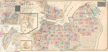
Map of the City of Ottawa Insurance Plan, 1888-1901 with business names and locations indicated
- Ashburnham - residential area downtown, bordered by Wellington St, Lyon St., Laurier Ave. and the Lebreton Aqueduct
- Bayswater - today part of the Hintonburg neighbourhood
- Baytown - today part of the Westboro neighbourhood
- Birchton - today part of the Westboro neighbourhood
- Britanniaville - included what is today the neighbourhoods of Britannia and Britannia Bay
- Cathartic - also known as Eastman's Springs; see Carlsbad Springs.
- Clandeboye - today part of Vanier
- Evansville - today located in the neighbourhood of Carlington
- Gateville - located just south of Billings Bridge
- Village of Gloucester - today part of the Lindenlea neighbourhood south of New Edinburgh
- Janeville - see Vanier
- Long Island Village - located opposite the north end of Long Island near the community of Manotick
- McLeansville - today part of Tunney's Pasture
- Merivale Village - today part of Carlington
- Mount Sherwood - 19th-century community located around where the Adult High School on Gladstone is today
- Nanny Goat Hill - 19th-century community today part of the LeBreton Flats, located at the foot of the eponymous Nanny Goat Hill
- Nepeanville - located where the Central Experimental Farm is today
- Parkview - today part of the Glebe
- Rideauville - today part of Old Ottawa South
- Rochesterville - today makes up Centretown West
- Rockville - also known as Rock Village, this neighbourhood developed around Gloucester Quarries opened by Antoine Robillard on Montreal Road
- Stewarton - today makes up The Glebe and Centretown
- St. Joseph - see Orléans
- Wellington - see Kars
- Willowdale - today part of the Eastway Gardens neighbourhood
Main communities
This is a list of the main communities in the Ottawa area along with population numbers.
Greater areas and CMAs
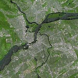
National Capital Region by SPOT Satellite in 2003
Cities
Former municipalities
- Former cities
- Ottawa (pop. 382,076) (Downtown Ottawa, The Glebe, Centretown, Lower Town, Sandy Hill, Billings Bridge)
- Cumberland (pop. 52,430) (former township, became city in 1999)
- Gloucester (pop. 110,264)
- Kanata (pop. 90,000)
- Nepean (pop. 124,878)
- Vanier (pop. 17,632)
- Former villages
- Rockcliffe Park (pop. 1,927)
- Former townships
Other main suburban areas
- Orleans (pop. 100,000) (located in the former cities of Cumberland and Gloucester)
- Barrhaven (pop. 70,000) (located in the former city of Nepean)
- Stittsville (pop. 18,913) (located in the former township of Goulbourn)
- Bells Corners (pop. 9,720)
- Blackburn Hamlet (pop. 8,955)
- Hunt Club (pop. 13,000)
- Morgan's Grant (pop. 8,000)
- Riverside South (pop. 8,000)
- Riverview (pop. 11,704)
Rural villages and hamlets
- Dalmeny, Ontario (pop. unknown)
- Pana, Ontario (pop. unknown)
- Antrim (pop. unknown)
- Corkery (pop. unknown)
- Dwyer Hill (pop. unknown)
- Burritts Rapids (pop. 100)
- Ashton (pop. 108)
- Galetta (pop. 177)
- Dunrobin (pop. 288)
- Kinburn (pop. 288)
- Kenmore (pop. 321)
- Fallowfield (pop. 366)
- Edwards (pop. 402)
- Sarsfield (pop. 474)
- Vernon (pop. 597)
- Kars (pop. 648)
- Fitzroy Harbour (pop. 654)
- Marionville (pop est. 900)
- Vars (pop. 981)
- Munster (pop. 1,320)
- Carp (pop. 1,416)
- Navan (pop. 1,593)
- North Gower (pop. 1,749)
- Cumberland (pop. 1,884)
- Metcalfe (pop. 2,070)
- Constance Bay (pop. 2,619)
- Osgoode (pop. 2,784)
- Richmond (pop. 3,301)
- Greely (pop. 4,395)
- Manotick (pop. 7,545)
See also
References
- 1 2 3 "Population" (PDF). Annual Development Report 2006. Retrieved 2008-02-08.
- ↑ "Population and dwelling counts, for Canada and census subdivisions (municipalities), 2006 and 2001 censuses - 100% data". 2006 Canadian Census. Retrieved 2007-10-10.
External links
| Wikimedia Commons has media related to List of neighbourhoods in Ottawa. |
- City of Ottawa: Neighbourhoods of Interest
- History of seven of Ottawa's urban communities: Virtual Museum of Canada Exhibit
| History | |
|---|---|
| Geography | |
| Culture | |
| Public services | |
| Education | |
| Government | |
| Transportation | |
| Features | |
| |
| Infrastructure | |
|---|---|
| Sport in Ottawa | |
| Entertainment and festivals | |
| Museums |
|
| Parks, squares, and natural landmarks | |
| Historical | |
| Demolished structures | |
| Shopping | |
| Neighbourhoods | |
| |
This article is issued from
Wikipedia.
The text is licensed under Creative Commons - Attribution - Sharealike.
Additional terms may apply for the media files.