Mesita, Colorado
| Mesita, Colorado | |
|---|---|
| Unincorporated community | |
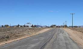 Mesita, viewed from the east along CR H. | |
 Location in Costilla County and the state of Colorado  Mesita, Colorado (the US) | |
| Coordinates: 37°05′52″N 105°36′08″W / 37.09778°N 105.60222°WCoordinates: 37°05′52″N 105°36′08″W / 37.09778°N 105.60222°W | |
| Country |
|
| State |
|
| County | Costilla[1] |
| Elevation[1] | 7,674 ft (2,339 m) |
| Time zone | UTC-7 (MST) |
| • Summer (DST) | UTC-6 (MDT) |
| ZIP code[2] | 81152 (San Luis) |
| GNIS feature ID | 0204792 |
Mesita is an unincorporated community in Costilla County, Colorado, United States. The U.S. Post Office at San Luis (ZIP Code 81152) now serves Mesita postal addresses.[2]
Reported UFO Activity
Mesita is reportedly the site of some of the San Luis Valley cow mutilations. Two cows and one horse were found east of Mesita with unexplainable mutilations, including a rectal coring, and signs of being dropped from a great height.[3]
Geography
Mesita is located at 37°05′52″N 105°36′08″W / 37.09778°N 105.60222°W (37.097908,-105.602131).
References
- 1 2 "US Board on Geographic Names". United States Geological Survey. 2007-10-25. Retrieved 2008-01-31.
- 1 2 "ZIP Code Lookup". United States Postal Service. January 3, 2007. Archived from the original (JavaScript/HTML) on January 1, 2008. Retrieved January 3, 2007.
- ↑ O'Brien, Christopher (June 2007). Secrets of the Mysterious Valley. Ventures Unlimited Press. p. 441. ISBN 1-931882-66-5.
Municipalities and communities of Costilla County, Colorado, United States | ||
|---|---|---|
| Towns | 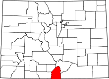 | |
| CDPs | ||
| Unincorporated communities | ||
| Ghost town | ||
This article is issued from
Wikipedia.
The text is licensed under Creative Commons - Attribution - Sharealike.
Additional terms may apply for the media files.