Garcia, Colorado
| Gracia, Colorado | |
|---|---|
| Unincorporated community | |
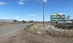 Entering Garcia from New Mexico. | |
| Coordinates: 37°00′12″N 105°32′12″W / 37.00333°N 105.53667°WCoordinates: 37°00′12″N 105°32′12″W / 37.00333°N 105.53667°W | |
| Country |
|
| State |
|
| Counties | Costilla[1] |
| Elevation[1] | 7,726 ft (2,355 m) |
| Time zone | UTC-7 (MST) |
| • Summer (DST) | UTC-6 (MDT) |
| ZIP code[2] | 81152 |
Garcia is an unincorporated community and a U.S. Post Office located in Costilla County, Colorado, United States, just north of the New Mexico border. The Garcia Post Office has the ZIP Code 81134.[2]
History
A post office called Garcia was established in 1915.[3] The community was named for the local Garcia family.[4]
Geography
Garcia is located at 37°00′12″N 105°32′12″W / 37.00333°N 105.53667°W (37.003375,-105.536728).
References
- 1 2 "US Board on Geographic Names". United States Geological Survey. 2007-10-25. Retrieved 2008-01-31.
- 1 2 "ZIP Code Lookup". United States Postal Service. December 15, 2006. Archived from the original (JavaScript/HTML) on November 23, 2010. Retrieved December 15, 2006.
- ↑ "Post offices". Jim Forte Postal History. Archived from the original on 6 March 2016. Retrieved 25 June 2016.
- ↑ Dawson, John Frank. Place names in Colorado: why 700 communities were so named, 150 of Spanish or Indian origin. Denver, CO: The J. Frank Dawson Publishing Co. p. 23.
Municipalities and communities of Costilla County, Colorado, United States | ||
|---|---|---|
| Towns | 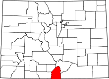 | |
| CDPs | ||
| Unincorporated communities | ||
| Ghost town | ||
This article is issued from
Wikipedia.
The text is licensed under Creative Commons - Attribution - Sharealike.
Additional terms may apply for the media files.