Meredith, Colorado
| Meredith, Colorado | |
|---|---|
| Unincorporated community | |
 Location in Pitkin County and the state of Colorado  Meredith, Colorado (the US) | |
| Coordinates: 39°21′44″N 106°43′50″W / 39.36222°N 106.73056°WCoordinates: 39°21′44″N 106°43′50″W / 39.36222°N 106.73056°W | |
| Country |
|
| State |
|
| County | Pitkin[1] |
| Elevation[1] | 7,772 ft (2,369 m) |
| Time zone | UTC-7 (MST) |
| • Summer (DST) | UTC-6 (MDT) |
| ZIP code[2] | 81642 |
| GNIS feature ID | 0179732 |
Meredith is an unincorporated community and a U.S. Post Office in Pitkin County, Colorado, United States. The Meredith Post Office has the ZIP Code 81642.[2]
Meredith was a limestone quarry town as well as a lumber camp in the 1890s. It is now mainly a "resort area". There are many original occupied buildings.
Geography
Meredith is located at 39°21′44″N 106°43′50″W / 39.36222°N 106.73056°W (39.362174,-106.730633).
References
- 1 2 "US Board on Geographic Names". United States Geological Survey. 2007-10-25. Retrieved 2008-01-31.
- 1 2 "ZIP Code Lookup". United States Postal Service. January 2, 2007. Archived from the original (JavaScript/HTML) on January 1, 2008. Retrieved January 2, 2007.
| Major cities | 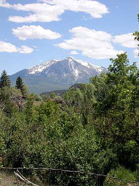 | |
|---|---|---|
| Other communities | ||
| Near valley | ||
| Ski resorts | ||
| Bodies of water | ||
Municipalities and communities of Pitkin County, Colorado, United States | ||
|---|---|---|
| City | 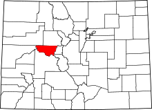 | |
| Towns | ||
| CDPs | ||
| Unincorporated communities | ||
| Ghost towns | ||
| Footnotes | ‡This populated place also has portions in an adjacent county or counties | |
This article is issued from
Wikipedia.
The text is licensed under Creative Commons - Attribution - Sharealike.
Additional terms may apply for the media files.