Lummen
| Lummen | |||
|---|---|---|---|
| Municipality | |||
 | |||
| |||
 Lummen Location in Belgium
Location of Lummen in Limburg 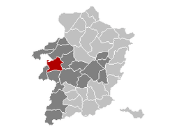 | |||
| Coordinates: 50°59′N 05°12′E / 50.983°N 5.200°ECoordinates: 50°59′N 05°12′E / 50.983°N 5.200°E | |||
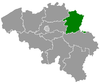
| Country | Belgium | ||
| Community | Flemish Community | ||
| Region | Flemish Region | ||
| Province | Limburg | ||
| Arrondissement | Hasselt | ||
| Government | |||
| • Mayor | Luc Wouters (CD&V) | ||
| • Governing party/ies | CD&V, sp.a | ||
| Area | |||
| • Total | 53.38 km2 (20.61 sq mi) | ||
| Population (1 January 2017)[1] | |||
| • Total | 14,662 | ||
| • Density | 270/km2 (710/sq mi) | ||
| Postal codes | 3560 | ||
| Area codes | 013, 011 | ||
| Website | www.lummen.be | ||

Lummen is a municipality located in the Belgian province of Limburg near Hasselt. On January 1, 2006, Lummen had a total population of 13,691. The total area is 53.38 km² which gives a population density of 256 inhabitants per km².
The municipality consists of the following sub-municipalities: Lummen proper, Meldert en Linkhout. In addition, it includes the following hamlets: Geneiken, Genenbos, Gestel, Goeslaar, Groenlaren, Laren, Mellaer, Molem, Oostereinde, Rekhoven, Schalbroek, and Thiewinkel.
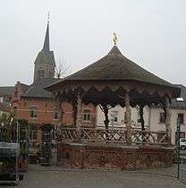
Kasteel Lagendal is situated in this municipality.
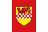
The historic coat of arms features the crests of the Houses of Arenberg, La Marck and Arrazola de Oñate. In 2008 however, the municipality chose to use a new logo on its official documents instead.
References
- ↑ Population per municipality as of 1 January 2017 (XLS; 397 KB)
External links

- Official website - Available only in Dutch
Places adjacent to Lummen | ||||||||||
|---|---|---|---|---|---|---|---|---|---|---|
| ||||||||||
This article is issued from
Wikipedia.
The text is licensed under Creative Commons - Attribution - Sharealike.
Additional terms may apply for the media files.