Mecidiyeköy
Mecidiyeköy is a neighbourhood located in the Şişli district of Istanbul, Turkey.[1] It is also one of the prominent business quarters of Istanbul.[2] It is situated between Fulya, Kuştepe, Gültepe, Esentepe, and Gülbahar neighbourhoods. According to the 2008 demographic data, the population of the neighbourhood is 20,331.[3]
The neighbourhood of Mecidiyeköy took its name from the Ottoman sultan Abdülmecid I, since the neighbourhood started to be settled during his reign.[4]
Access
Mecidiyeköy is an important passenger transport hub on the European part of Istanbul.
- Metrobus lines:
- 34 (Zincirlikuyu-Avcılar),
- 34A (Söğütlüçeşme-Cevizlibağ),
- 34G (Söğütlüçeşme-TUYAP),
- Metro line: M2 (Hacıosman-Şişhane)
- Bus lines: with terminus Mecidiyeköy only[5]
- 25G Sarıyer - Hacıosman - Taksim
- 30A Beşiktaş
- 30M Beşiktaş
- 32M Cevatpaşa
- 33ÇM Bağcılar Dev.Hastanesi - Çinçindere Caddesi
- 33M Giyimkent - T.Reis
- 33TM Turgut Reis
- 36M Cebeci Mahallesi
- 36EM Cebeci Mahallesi
- 37M Yıldıztabya
- 41M Ayazağa Köyü
- 48 Göktürk
- 48H Hamidiye Mahallesi
- 54HT Hasköy - Taksim
- 55M Eyüp Üçşehitler
- 59C Arnavutköy
- 69A Yenikapı
- 75M Beyazıt & Aksaray
- 75O Otogar
- 76M Avcılar Metrobüs
- 77MT Edirnekapı - Taksim
- 78M Başakşehir 4. Etap
- 78BE Başakşehir 4. Etap
- 79M Kayaşehir
- 85 Bakırköy
- 85B Basın Sitesi
- 85G Güngören
- 85M Yenibosna Metro
- 92Ş Ateştuğla
- 93M Zeytinburnu
- 97İM İştoç
- 97M Güneşli
- 120 Kadıköy
- 120M Kadıköy
- 121A Beykoz
- 121B Kavacık
- 121BS Sultaniye - Soğuksu Mahallesi
- 122B Yenidoğan
- 122C Ümraniye
- 122D Cumhuriyet Mahallesi
- 122M Ş. Şahinbey
- 124, 128 Altbostancı
- 129 Altunizade
- 129K Kozyatağı
- 141M Kss Eğt.Ve Arş. Hastanesi
- 145M Beylikdüzü
- 146M Başakşehir 4. Etap
- 146E Başakşehir 4. Etap
- 253 Batı Ataşehir - Taksim
- 336M Arnavutköy
- 522ST Sultanbeyli
- E-55 İ. Marmara Evleri
- E-58 Esenkent
- E-59 Atakent
- E-60 Mimar Sinan
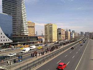
The motorway ![]()
See also
References
- ↑ "Neighbourhoods of the Şişli district" (in Turkish). Governorship of Şişli, Istanbul. 2009. Archived from the original on July 23, 2009. Retrieved 2009-08-01.
- ↑ Bridge, Gary; Sophie Watson (2002). A Companion to the City. Wiley-Blackwell. p. 342. ISBN 978-0-631-23578-1. Retrieved 2009-08-01.
- ↑ "Information on the Mecidiyeköy neighbourhood" (in Turkish). Municipality of Şişli, Istanbul. 2009. Archived from the original on 2007-12-14. Retrieved 2009-08-01.
- ↑ "Brief History of Mecidiyeköy" (in Turkish). Municipality of Şişli, Istanbul. 2009. Archived from the original on 2010-03-02. Retrieved 2009-08-01.
- ↑ "Tüm Otobüs Seferleri ve Otobüs Kodları" (in Turkish). Otobüste Gördüm. Retrieved 2012-02-04.
External links
| Wikimedia Commons has media related to Mecidiyeköy. |
Coordinates: 41°04′N 29°00′E / 41.067°N 29.000°E