Meadow Lakes, Alaska
| Meadow Lakes, Alaska | |
|---|---|
| CDP | |
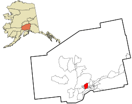 Location in Matanuska-Susitna Borough and the state of Alaska. | |
 Meadow Lakes, Alaska Location within the state of Alaska | |
| Coordinates: 61°35′59″N 149°36′58″W / 61.59972°N 149.61611°WCoordinates: 61°35′59″N 149°36′58″W / 61.59972°N 149.61611°W | |
| Country | United States |
| State | Alaska |
| Borough | Matanuska-Susitna |
| Government | |
| • Borough mayor | Vern Halter |
| • State senators |
Mike Shower (R) David Wilson (R) |
| • State reps. |
David Eastman (R) Mark Neuman (R) Colleen Sullivan-Leonard (R) |
| Area | |
| • Total | 70.0 sq mi (181.2 km2) |
| • Land | 67.0 sq mi (173.4 km2) |
| • Water | 3.0 sq mi (7.8 km2) |
| Elevation | 377 ft (115 m) |
| Population (2010) | |
| • Total | 7,570 Ranked 13th |
| Time zone | UTC-9 (Alaska (AKST)) |
| • Summer (DST) | UTC-8 (AKDT) |
| Area code(s) | 907 |
| FIPS code | 02-47735 |
| GNIS feature ID | 1866961 |
Meadow Lakes is a census-designated place (CDP) in Matanuska-Susitna Borough, Alaska, United States. It is part of the Anchorage, Alaska Metropolitan Statistical Area. As of the 2010 census, the population was 7,570, up from 4,819 in 2000.
Geography
Meadow Lakes is located at 61°35′59″N 149°36′58″W / 61.59972°N 149.61611°W (61.599661, -149.616036).[1]
According to the United States Census Bureau, the CDP has a total area of 70.0 square miles (181 km2), of which, 67.0 square miles (174 km2) of it is land and 3.0 square miles (7.8 km2) of it (4.32%) is water.
Demographics
| Historical population | |||
|---|---|---|---|
| Census | Pop. | %± | |
| 1990 | 2,374 | — | |
| 2000 | 4,819 | 103.0% | |
| 2010 | 7,570 | 57.1% | |
| U.S. Decennial Census[2] | |||
Meadow Lakes first reported on the 1990 U.S. Census as a census-designated place (CDP).
As of the census[3] of 2000, there were 4,819 people, 1,702 households, and 1,215 families residing in the CDP. The population density was 72.0 people per square mile (27.8/km²). There were 2,003 housing units at an average density of 29.9/sq mi (11.5/km²). The racial makeup of the CDP was 87.86% White, 0.54% Black or African American, 5.42% Native American, 0.60% Asian, 0.21% Pacific Islander, 0.58% from other races, and 4.79% from two or more races. 3.01% of the population were Hispanic or Latino of any race.
There were 1,702 households out of which 42.5% had children under the age of 18 living with them, 55.1% were married couples living together, 9.2% had a female householder with no husband present, and 28.6% were non-families. 20.9% of all households were made up of individuals and 3.3% had someone living alone who was 65 years of age or older. The average household size was 2.83 and the average family size was 3.30.
In the CDP, the population was spread out with 33.4% under the age of 18, 7.1% from 18 to 24, 32.5% from 25 to 44, 22.2% from 45 to 64, and 4.9% who were 65 years of age or older. The median age was 33 years. For every 100 females, there were 113.8 males. For every 100 females age 18 and over, there were 111.5 males.
The median income for a household in the CDP was $41,030, and the median income for a family was $47,534. Males had a median income of $40,948 versus $26,148 for females. The per capita income for the CDP was $17,295. About 12.3% of families and 17.1% of the population were below the poverty line, including 23.7% of those under age 18 and 5.0% of those age 65 or over.
References
- ↑ "US Gazetteer files: 2010, 2000, and 1990". United States Census Bureau. 2011-02-12. Retrieved 2011-04-23.
- ↑ "U.S. Decennial Census". Census.gov. Retrieved June 6, 2013.
- ↑ "American FactFinder". United States Census Bureau. Retrieved 2008-01-31.
Municipalities and communities of Matanuska-Susitna Borough, Alaska, United States | ||
|---|---|---|
| Cities | 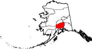 | |
| CDPs | ||
| Unincorporated communities | ||