Knik-Fairview, Alaska
| Knik-Fairview, Alaska | |
|---|---|
| CDP | |
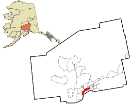 Location in Matanuska-Susitna Borough and the state of Alaska. | |
 Knik-Fairview, Alaska Location within the state of Alaska | |
| Coordinates: 61°31′39″N 149°35′53″W / 61.52750°N 149.59806°WCoordinates: 61°31′39″N 149°35′53″W / 61.52750°N 149.59806°W | |
| Country | United States |
| State | Alaska |
| Borough | Matanuska-Susitna |
| Government | |
| • Borough mayor | Vern Halter |
| • State senators |
Shelley Hughes (R) David Wilson (R) |
| • State reps. |
Mark Neuman (R) Colleen Sullivan-Leonard (R) Cathy Tilton (R) |
| Area | |
| • Total | 71.0 sq mi (183.9 km2) |
| • Land | 69.8 sq mi (180.8 km2) |
| • Water | 1.2 sq mi (3.1 km2) |
| Population (2010) | |
| • Total | 14,923 Ranked 5th |
| • Density | 179.6/sq mi (39.0/km2) |
| Time zone | UTC-9 (Alaska (AKST)) |
| • Summer (DST) | UTC-8 (AKDT) |
| Area code(s) | 907 |
| FIPS code | 02-40645 |
Knik-Fairview is a census-designated place (CDP) in Matanuska-Susitna Borough, Alaska, United States. It is part of the Anchorage, Alaska Metropolitan Statistical Area. At the 2010 census the population was 14,923, up from 7,049 in 2000.
Geography
Knik-Fairview is located at 61°31′39″N 149°35′53″W / 61.527579°N 149.597947°W.[1] 17.5 miles (28.2 km) northeast of Anchorage on the west bank of the Knik Arm of Cook Inlet; 13 miles south of Wasilla.
According to the United States Census Bureau, the CDP has a total area of 180 km2 (69 sq mi). Two percent, or 1 square mile (2.6 km2), of it is water.
Demographics
| Historical population | |||
|---|---|---|---|
| Census | Pop. | %± | |
| 1910 | 118 | — | |
| 1920 | 40 | −66.1% | |
| 1930 | 34 | −15.0% | |
| 1940 | 40 | 17.6% | |
| 1980 | 10 | — | |
| 1990 | 272 | 2,620.0% | |
| 2000 | 7,049 | 2,491.5% | |
| 2010 | 14,923 | 111.7% | |
| U.S. Decennial Census[2] | |||
Knik-Fairview first appeared on the 1910 U.S. Census as the unincorporated village of Knik.[3] It appeared again from 1920-40. Knik did not appear again until 1980, when it was classified as a native village with just 10 residents.[4] In 1990, it was reclassified as a census-designated place (CDP). In 2000, it was renamed Knik-Fairview (CDP).
As of the 2000 census, there were 7,050 people, 2,380 households, and 1,800 families residing in the CDP. The population density was 39/km² (100/sq mi). There were 2,590 housing units at an average density of 37/sq mi (14/km²). The racial makeup of the CDP was 88% white, 6% Native American, and 4% from two or more races. 3% of the population were Hispanic or Latino of any race. Blacks, Asians, and Pacific Islanders all have less than 1% . 1% are from other races.
There were 2,380 households out of which 45% had children under the age of 18 living with them, 64% were married couples living together, 7% had a female householder with no husband present, and 24% were non-families. 18% of all households were made up of individuals and 3% had someone living alone who was 65 years of age or older. The average household size was 3.0 and the average family size was 3.4.
In the CDP, the population was spread out with 34% under the age of 18, 6% from 18 to 24, 33% from 25 to 44, 23% from 45 to 64, and 5% who were 65 years of age or older. The median age was 33 years. For every 100 females, there were 108 males. For every 100 females age 18 and over, there were 107 males.
The median income for a household in the CDP was $52,100, and the median income for a family was $60,100. Males had a median income of $46,300 versus $29,800 for females. The per capita income for the CDP was $20,900. 11% of the population and 9% of families were below the poverty line. 13% of those under the age of 18 and 4% of those 65 and older were living below the poverty line.
References
- ↑ "US Gazetteer files: 2010, 2000, and 1990". United States Census Bureau. 2011-02-12. Retrieved 2011-04-23.
- ↑ "U.S. Decennial Census". Census.gov. Retrieved June 6, 2013.
- ↑ https://books.google.com/books?id=Rr9RAQAAMAAJ&pg=PA49&lpg=PA49&dq=%22Agaligamute%22&source=bl&ots=Tzy-F6Dup7&sig=B81GmrTlcKv3jtL_iWMYTwV3FSo&hl=en&sa=X&ved=0ahUKEwj69sDB-MLUAhXD2T4KHTt1Dc0Q6AEILjAD#v=onepage&q=knik&f=false
- ↑ https://www2.census.gov/prod2/decennial/documents/1980a_akABCD-01.pdf
Municipalities and communities of Matanuska-Susitna Borough, Alaska, United States | ||
|---|---|---|
| Cities | 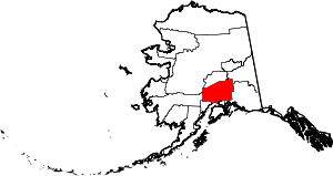 | |
| CDPs | ||
| Unincorporated communities | ||