McMinn County Airport
| McMinn County Airport | |||||||||||
|---|---|---|---|---|---|---|---|---|---|---|---|
 | |||||||||||
| Summary | |||||||||||
| Airport type | Public | ||||||||||
| Owner | McMinn County | ||||||||||
| Serves | Athens, Tennessee | ||||||||||
| Elevation AMSL | 858 ft / 262 m | ||||||||||
| Coordinates | 35°23′50″N 084°33′45″W / 35.39722°N 84.56250°W | ||||||||||
| Map | |||||||||||
 MMI Location of airport in Tennessee | |||||||||||
| Runways | |||||||||||
| |||||||||||
| Statistics (1998) | |||||||||||
| |||||||||||
McMinn County Airport (IATA: MMI, ICAO: KMMI, FAA LID: MMI) is a county-owned, public-use airport located three nautical miles (6 km) southeast of the central business district of Athens, a city in McMinn County, Tennessee, United States.[1]
Facilities and aircraft
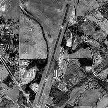
McMinn County Airport covers an area of 76 acres (31 ha) at an elevation of 858 feet (262 m) above mean sea level. It has one runway designated 2/20 with a 6,450 by 75 ft (1,966 x 23 m) asphalt surface.[1]
For the 12-month period ending December 16, 1998, the airport had 30,000 aircraft operations, an average of 82 per day: 98% general aviation, 2% air taxi and <1% military. At that time there were 63 aircraft based at this airport: 95% single-engine, 3% multi-engine and 2% jet.[1]
The Fixed-base operator at McMinn County airport is Athens Air, LLC
The airport is attended from 0830 to Dusk and has 100LL aviation fuel and Jet A. It is included under the Nashville FSS. It has medium intensity runway lighting, REIL on Runway 02, and VASI on both runways. NOTAMs are filed with Nashville International Airport.[2][3]
See also
References
- 1 2 3 4 FAA Airport Master Record for MMI (Form 5010 PDF), effective 2008-04-10
- ↑ Athens / McMinn Co. (MMI) at FAA Airport/Facility Directory, effective 2008-04-10
- ↑ McMinn County - MMI at Tennessee DOT Airport Directory
External links
- Resources for this airport:
- FAA airport information for MMI
- AirNav airport information for MMI
- ASN accident history for MMI
- FlightAware airport information and live flight tracker
- SkyVector aeronautical chart for MMI