McKenzie, Alabama
| McKenzie, Alabama | |
|---|---|
| Town | |
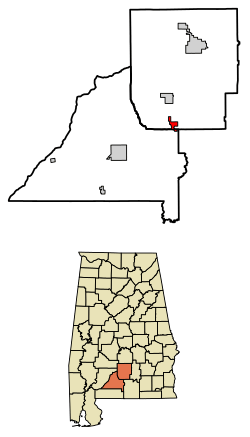 Location of McKenzie in Butler County and Conecuh County, Alabama. | |
| Coordinates: 31°32′34″N 86°43′11″W / 31.54278°N 86.71972°W | |
| Country | United States |
| State | Alabama |
| Counties | Butler, Conecuh |
| Area[1] | |
| • Total | 3.74 sq mi (9.69 km2) |
| • Land | 3.72 sq mi (9.64 km2) |
| • Water | 0.02 sq mi (0.04 km2) |
| Elevation | 453 ft (138 m) |
| Population (2010) | |
| • Total | 530 |
| • Estimate (2017)[2] | 501 |
| • Density | 134.53/sq mi (51.95/km2) |
| Time zone | UTC-6 (Central (CST)) |
| • Summer (DST) | UTC-5 (CDT) |
| ZIP code | 36456 |
| Area code | 334 |
| FIPS code | 01-45496 |
| GNIS feature ID | 0122435 |
McKenzie is a town in Butler and Conecuh counties in the U.S. state of Alabama. The population was 644 at the 2000 census and had decreased to 530 as of the 2010 census.[3]
Geography
McKenzie is located in southern Butler County at 31°32′34″N 86°43′11″W / 31.54278°N 86.71972°W (31.542801, -86.719772).[4] A portion of the town extends south into Conecuh County. U.S. Route 31 passes to the west of the town center, leading north 23 miles (37 km) to Greenville, the Butler County seat, and southwest 19 miles (31 km) to Evergreen, the Conecuh County seat. State Route 55 leads southeast from McKenzie 23 miles (37 km) to Andalusia.
According to the United States Census Bureau, McKenzie has a total area of 3.7 square miles (9.7 km2), of which 0.015 square miles (0.04 km2), or 0.45%, is water.[3]
Demographics
| Historical population | |||
|---|---|---|---|
| Census | Pop. | %± | |
| 1920 | 293 | — | |
| 1930 | 396 | 35.2% | |
| 1940 | 504 | 27.3% | |
| 1950 | 504 | 0.0% | |
| 1960 | 558 | 10.7% | |
| 1970 | 491 | −12.0% | |
| 1980 | 605 | 23.2% | |
| 1990 | 464 | −23.3% | |
| 2000 | 644 | 38.8% | |
| 2010 | 530 | −17.7% | |
| Est. 2017 | 501 | [2] | −5.5% |
| U.S. Decennial Census[5] 2013 Estimate[6] | |||
As of the census[7] of 2000, there were 644 people, 284 households, and 170 families residing in the town. The population density was 171.4 people per square mile (66.1/km²). There were 324 housing units at an average density of 86.2 per square mile (33.3/km²). The racial makeup of the town was 76.09% White, 22.52% Black or African American, 0.47% Native American, 0.16% Asian, and 0.78% from two or more races. 0.31% of the population were Hispanic or Latino of any race.
There were 284 households out of which 28.2% had children under the age of 18 living with them, 40.8% were married couples living together, 16.2% had a female householder with no husband present, and 40.1% were non-families. 37.7% of all households were made up of individuals and 22.2% had someone living alone who was 65 years of age or older. The average household size was 2.27 and the average family size was 3.04.
In the town, the age distribution of the population shows 25.3% under the age of 18, 7.5% from 18 to 24, 24.5% from 25 to 44, 21.4% from 45 to 64, and 21.3% who were 65 years of age or older. The median age was 41 years. For every 100 females, there were 86.1 males. For every 100 females age 18 and over, there were 77.5 males.
The median income for a household in the town was $18,173, and the median income for a family was $24,423. Males had a median income of $23,077 versus $16,071 for females. The per capita income for the town was $10,359. About 21.1% of families and 27.5% of the population were below the poverty line, including 34.3% of those under age 18 and 33.3% of those age 65 or over.
Education
McKenzie High School is a K-12 school located in McKenzie.
Notable People
Earnie Shavers Professional boxer was born in Garland, Alabama. A small rural community in McKenzie.
References
- ↑ "2017 U.S. Gazetteer Files". United States Census Bureau. Retrieved Jul 7, 2018.
- 1 2 "Population and Housing Unit Estimates". Retrieved March 24, 2018.
- 1 2 "Geographic Identifiers: 2010 Demographic Profile Data (G001): McKenzie town, Alabama". U.S. Census Bureau, American Factfinder. Retrieved September 18, 2013.
- ↑ "US Gazetteer files: 2010, 2000, and 1990". United States Census Bureau. 2011-02-12. Retrieved 2011-04-23.
- ↑ "U.S. Decennial Census". Census.gov. Archived from the original on May 12, 2015. Retrieved June 6, 2013.
- ↑ "Annual Estimates of the Resident Population: April 1, 2010 to July 1, 2013". Retrieved June 3, 2014.
- ↑ "American FactFinder". United States Census Bureau. Archived from the original on September 11, 2013. Retrieved 2008-01-31.
Coordinates: 31°32′34″N 86°43′11″W / 31.542801°N 86.719772°W
Municipalities and communities of Butler County, Alabama, United States | ||
|---|---|---|
| City | 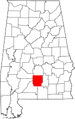 | |
| Towns | ||
| Unincorporated communities | ||
| Footnotes | ‡This populated place also has portions in an adjacent county or counties | |
Municipalities and communities of Conecuh County, Alabama, United States | ||
|---|---|---|
| City | 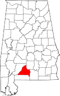 | |
| Towns | ||
| Unincorporated communities | ||
| Footnotes | ‡This populated place also has portions in an adjacent county or counties | |