McFarland Peak
| McFarland Peak | |
|---|---|
 | |
| Highest point | |
| Elevation | 10,749 ft (3,276 m) NAVD 88[1] |
| Prominence | 1,165 ft (355 m) [1] |
| Coordinates | 36°20′29″N 115°43′32″W / 36.3413504°N 115.725576°WCoordinates: 36°20′29″N 115°43′32″W / 36.3413504°N 115.725576°W [2] |
| Geography | |
 McFarland Peak | |
| Parent range | Spring Mountains |
| Topo map | USGS Charleston Peak |
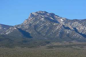
McFarland Peak is a limestone peak in the northern portion of the Spring Mountains in Clark County of southern Nevada. It is in the Toiyabe National Forest and the Mount Charleston Wilderness.
McFarland Peak is located north of Mount Charleston.
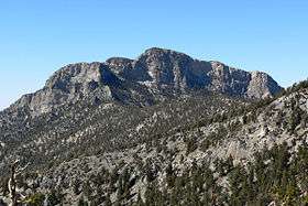
McFarland Peak seen from Indian Ridge
References
- 1 2 "McFarland Peak, Nevada". Peakbagger.com. Retrieved 2010-10-01.
- ↑ "McFarland Peak". Geographic Names Information System. United States Geological Survey. Retrieved 2010-10-01.
External links
- "McFarland Peak". SummitPost.org.
This article is issued from
Wikipedia.
The text is licensed under Creative Commons - Attribution - Sharealike.
Additional terms may apply for the media files.