McArthur Lake (Saskatchewan)
| McArthur Lake | |
|---|---|
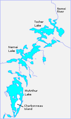 McArthur, Nemei and Tocher lakes drain into the Nemei River | |
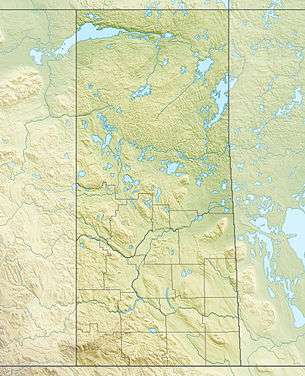 McArthur Lake Location is Saskatchewan | |
| Coordinates | 55°15′00″N 102°24′01″W / 55.2501°N 102.4004°WCoordinates: 55°15′00″N 102°24′01″W / 55.2501°N 102.4004°W |
| Type | Lake |
| Basin countries | Canada |
| Surface elevation | 328 metres (1,076 ft) |
McArthur Lake is a lake in Saskatchewan, Canada. It lies in low-relief terrain of the Canadian Shield. The climate is sub-arctic. The land is mostly covered by conifer forests, with some areas of muskeg and rocky outcrops.
Location
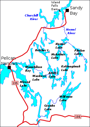
McArthur Lake is at 55°15′00″N 102°24′01″W / 55.2501°N 102.4004°W, at an elevation of 328 metres (1,076 ft).[1][lower-alpha 1] The lake contains Charbonneau Island.[3] It is northwest of Flin Flon, Manitoba, and east of Pelican Narrows, Saskatchewan.[4] McArthur Lake drains northward into the Churchill River via the Nemei River.[4] The lake is named in honour of Duncan Archibald McArthur, a private soldier who died on 28 August 1944 during the Allied invasion of Normandy.[5]
Terrain
The Attitti Lake region, which includes McArthur Lake, is typical of the flat-surfaced part of the Canadian Shield, with low hills that rarely rise as much as 100 to 150 feet (30 to 46 m) above the lakes.[4] The terrain consists of roughly parallel sinuous ridges of outcrop separated by muskeg, drift and lakes.[4] Geologically the area is in the Precambrian Kisseynew complex, underlain by an assemblage of metamorphosed sedimentary rocks that has been intricately folded, with intrusions of sill-like granitic bodies.[6]
In its northern section the McArthur Lake fault zone is parallel to the east shore of McArthur Lake, forming a steep scarp 75 to 100 feet (23 to 30 m) high. The fault zone runs south to a location about 1 mile (1.6 km) north of Galbraith Lake.[7] The Galbraith Lake folds is an open asymmetric overturned syncline with an axial plane trending 25° NE, dipping very sharply to the east, that extends south from the south end of McArthur Lake to the south of Galbraith Lake.[8] There are a number of northerly plunging folds between McArthur and Kakinagimak lakes with axial planes 20° NE, dipping sharply to the east.[9]
Environment
The lake is in the subarctic climate zone.[10] The annual average temperature is −2 °C (28 °F). The warmest month is July, when the average temperature is 16 °C (61 °F) and the coldest is January, with −29 °C (−20 °F).[11] The lake is surrounded by coniferous forest.[12] The trees are mainly black spruce (Picea mariana), jack pine (Pinus banksiana), poplar (populus) and scattered balsam (populus balsamifera). Trees average more than 20 feet (6.1 m) in height.[4] There are small patches of moss-covered muskeg that support laurel (kalmia microphylla), labrador tea, and scattered larch and black spruce.[13]
Animals hunted for meat or fur include moose, woodland cariboo, black bear, beaver, otter and muskrat. Spruce partridge are common.[13]
Minerals
Dark gray to black garnet-hornblende gneiss is exposed in an area from north of Bentz Bay to just south of McArthur Lake.[14] Small areas of hornblende and/or biotite migmatite are found near the lake. The light to dark gray outcrops are usually rounded and weathered.[15] Dykes, lenses, and veins of pegmatite are abundant in the meta-sedimentary rocks and granitic bodies between the north of Attitti Lake and McArthur Lake.[16] The northeast shore of Charbonneau Island has chalcopyrite and pyrite associated with stringers of pink pegmatite in biotite-hornblende migmatite. In 1958 the Hudson Bay Exploration and Development Company staked claims to this area based on a aerial electromagnetic and magnetometer survey. The company undertook a geophysical survey and some diamond drilling, then allowed the claims to lapse.[17]
Notes
- ↑ There is another McArthur Lake in Saskatchewan at 52°34′0″N 104°22′0″W / 52.56667°N 104.36667°W.[2]
Citations
- ↑ McArthur Lake – Mapcarta.
- ↑ Gazetteer of Canada: Saskatchewan, p. 51.
- ↑ Pyke 1961, p. 28.
- 1 2 3 4 5 Pyke 1961, p. 5.
- ↑ Duncan Archibald McArthur.
- ↑ Pyke 1961, p. 8.
- ↑ Pyke 1961, p. 20.
- ↑ Pyke 1961, p. 18.
- ↑ Pyke 1961, p. 19.
- ↑ Peel, Finlayson & McMahon 2007.
- ↑ Dataset Index – NASA.
- ↑ Land Cover Classification – NASA.
- 1 2 Pyke 1961, p. 6.
- ↑ Pyke 1961, p. 9.
- ↑ Pyke 1961, p. 14.
- ↑ Pyke 1961, p. 17.
- ↑ Pyke 1961, p. 21.
Sources
- "Dataset Index", NASA Earth Observations Data, NASA, retrieved 30 January 2016
- "Duncan Archibald McArthur", Canadian Virtual War Memorial, Veterans Affairs Canada, retrieved 2018-06-29
- Gazetteer of Canada: Saskatchewan (PDF) (4 ed.), Ottawa: Natural Resources Canada, 1998, ISBN 978-1-100-54786-2, retrieved 2018-06-29
- "Land Cover Classification (1 year)", NASA Earth Observations Data, NASA, retrieved 30 January 2016
- "McArthur Lake", Mapcarta, retrieved 2018-06-24
- Peel, M C; Finlayson, B L; McMahon, T A (2007), "Updated world map of the Köppen-Geiger climate classification", Hydrology and Earth System Sciences 11, doi:10.5194/hess-11-1633-2007
- Pyke, M. W. (1961), The Geology of the Attitti Lake Area (West Half) Saskatchewan (PDF), Saskatchewan Department of Mineral Resources, retrieved 2018-06-24