McAllen–Hidalgo–Reynosa International Bridge
| McAllen–Hidalgo–Reynosa International Bridge | |
|---|---|
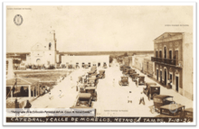 Bridge's opening day celebration on 10 July 1926 in the plaza of Reynosa, Mexico. | |
| Coordinates | 26°05′42″N 98°16′17″W / 26.095°N 98.2714°WCoordinates: 26°05′42″N 98°16′17″W / 26.095°N 98.2714°W |
| Crosses |
Rio Grande, Mexico–United States border |
| Locale |
McAllen−Hidalgo, Texas, United States; Reynosa, Tamaulipas state, Mexico |
| Characteristics | |
| No. of spans | 2 |
| History | |
| Opened | 1926 |
The McAllen–Hidalgo–Reynosa International Bridge is a road bridge completed in 1926, crossing the Rio Grande between the state of Tamaulipas in northeastern Mexico and the state of Texas in the southwestern United States.
Route
The Hidalgo Texas Port of Entry is associated with the bridge that connects the cities of Hidalgo and McAllen in Texas to the city of Reynosa in Tamaulipas.
The road bridge has two spans, north and south bound, of four lanes each.
Jurisdictions
The American portion of the bridge is within Hidalgo, but is operated-maintained by the larger city of McAllen to the north. It is one of the largest operations undertaken by McAllen to date.
Crossing the bridge north into Texas can take up to 1-2 hours at the Hidalgo Texas Port of Entry, as the U.S. border agents stop all vehicles and the lines can be very long. Recently a Secure Electronic Network for Travelers Rapid Inspection−SENTRI lane was designated, which for an extra yearly fee shortens the U.S. entry time from Mexico.
Crossing the bridge south into Tamaulipas is generally quicker, as the Mexican border agents usually check few incoming vehicles.
Since 1996, all northbound trucks are required to use the Pharr–Reynosa International Bridge to enter the U.S.
See also
- Anzalduas International Bridge — next Reynosa + McAllen road bridge upriver-west.
- Bridges over the Rio Grande
Coordinates: 26°5′42″N 98°16′17″W / 26.09500°N 98.27139°W