Ciudad Madero
| Ciudad Madero, Tamaulipas | ||
|---|---|---|
| City | ||
| Ciudad Madero | ||
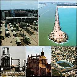 Top Left: Downtown, Miramar Beach Breakwater, Francisco I. Madero Refinery, Sagrado Corazón de Jesús Church, Tamaulipas Stadium. | ||
| ||
|
Ciudad Madero, Tamaulipas | ||
| Coordinates: 22°15′N 97°50′W / 22.250°N 97.833°WCoordinates: 22°15′N 97°50′W / 22.250°N 97.833°W | ||
| Country |
| |
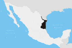
| State |
| |
| Municipality | Ciudad Madero | |
| Foundation | May 1, 1924 | |
| Founded by | Doña Cecilia Villarreal | |
| Government | ||
| • Mayor |
José Andrés Zorrilla Moreno | |
| Area | ||
| • Total | 46.6 km2 (18.0 sq mi) | |
| Elevation | 8 m (26 ft) | |
| Population (2015) | ||
| • Total | 209,175 | |
| • Demonym | Maderense | |
| Time zone | UTC−6 (CST) | |
| • Summer (DST) | UTC−5 (CDT) | |

Ciudad Madero is a coastal city, located in southeast Tamaulipas in the Gulf of Mexico, It is the seventh most populous city in the state, with a census-estimated 2015 population of 209,175 within an area of 18.0 square miles (46.6 km2) the city is the third-largest in the Tampico metropolitan area, It is also an important center of oil refining in Mexico.
Ciudad Madero has a beach named "Playa Miramar", which, in recent years, has been expanding its services with new hotels and restaurants. Near the beach there is a lighthouse, named "Faro de Ciudad Madero" - although this has been replaced by a red beacon light atop a small tower, to guide approaching ships in to the channel of the Río Pánuco. However, in October 2006, the Ciudad Madero Planning Commission signaled its intention to build a new lighthouse because of the cultural and tourist values it would provide.
References
- Link to tables of population data from Census of 2005 INEGI: Instituto Nacional de Estadística, Geografía e Informática
- Tamaulipas Enciclopedia de los Municipios de México
External links
- Ayuntamiento de Ciudad Madero Official website