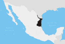
Gómez Farías Municipality, Tamaulipas
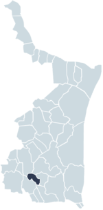
Gómez Farías Municipality is a municipality located in the Mexican state of Tamaulipas. The seat of government for the municipality is the town Gómez Farías. Gomez Farias Municipality has an area of 433 square kilometres (167 sq mi) and a population in 2010 of 8,786. The town of Gomez Farias in 2010 had a population of 883.[1] 23,124 hectares (57,140 acres) (231 sq. km.) of the municipal area is included in the El Cielo Biosphere reserve.[2]
In 1749 a settlement was established on the site of Gomez Farias to concentrate the semi-nomadic Indians of the area into a single community. On 10 January 1869 the municipality was created and named for Valentín Gómez Farías, a former President of Mexico.[3]
Climate
Most of the State of Tamaulipas is semi-arid and typically covered in a thorny scrub vegetation called Tamaulipan Mezquital. Gomez Farias and a few other areas on the eastern slopes of the Sierra Madre Oriental are the exception with high precipitation and luxuriant vegetation. El Cielo Biosphere is the most northerly area in Mexico of tropical Veracruz moist forests. Temperate Cloud forests are found at higher elevations.[4]
| Climate data for Gomez Farias, Tamaulipas. 23 03 N, 99 09W. Elevation: 327 metres (1,073 ft) | |||||||||||||
|---|---|---|---|---|---|---|---|---|---|---|---|---|---|
| Month | Jan | Feb | Mar | Apr | May | Jun | Jul | Aug | Sep | Oct | Nov | Dec | Year |
| Average high °C (°F) | 22.5 (72.5) |
24.7 (76.5) |
28.3 (82.9) |
30.9 (87.6) |
32.2 (90) |
32.2 (90) |
31.7 (89.1) |
32.3 (90.1) |
30.8 (87.4) |
28.7 (83.7) |
25.9 (78.6) |
22.9 (73.2) |
28.6 (83.5) |
| Daily mean °C (°F) | 17.3 (63.1) |
19.1 (66.4) |
22.3 (72.1) |
24.9 (76.8) |
26.7 (80.1) |
27.0 (80.6) |
26.8 (80.2) |
27.1 (80.8) |
26.0 (78.8) |
23.9 (75) |
20.9 (69.6) |
18.9 (66) |
23.3 (73.9) |
| Average low °C (°F) | 12.2 (54) |
13.4 (56.1) |
16.4 (61.5) |
18.9 (66) |
21.3 (70.3) |
21.9 (71.4) |
21.8 (71.2) |
21.9 (71.4) |
21.2 (70.2) |
19.0 (66.2) |
16.0 (60.8) |
13.1 (55.6) |
16.1 (61) |
| Average precipitation mm (inches) | 31 (1.22) |
30 (1.18) |
47 (1.85) |
77 (3.03) |
172 (6.77) |
323 (12.72) |
365 (14.37) |
270 (10.63) |
289 (11.38) |
153 (6.02) |
50 (1.97) |
39 (1.54) |
1,847 (72.72) |
| Source: Weatherbase: Gomez Farias, Tamaulipas.[5] | |||||||||||||
Economy
Sugar cane, mostly grown with irrigation, is by far the most important agricultural product of the municipality. Cattle, Citrus, and mango are also important. In the mountainous part of the municipality, maize is the principal crop, grown mostly by small-scale farmers. Gomez Farias attracts a sizable number of visitors, including bird watchers and botanists, to the El Cielo Biosphere and scenic areas along the Sabinas and Frio rivers.[6]
External links
- http://www.gomezfarias.gob.mx/ Website of Gomez Farias.
Coordinates: 23°02′N 99°09′W / 23.033°N 99.150°W
References
- ↑ http://www.campotamaulipas.gob.mx/oeidrus/pdfs/basica/gomez_farias.pdf, accessed 19 Dec 2014
- ↑ "Comision Nacional para el Conocimiento y Uso de la Biodiversidad," http://www2.inecc.gob.mx/publicaciones/libros/2/cielo.html, accessed 23 Dec 2014
- ↑ http://www.campotamaulipas.gob.mx/oeidrus/pdfs/basica/gomez_farias.pdf, accessed 19 Dec 2014
- ↑ "Gomez Farias Region and El Cielo Biosphere Reserve", "Archived copy". Archived from the original on 2015-03-05. Retrieved 2014-12-18. , accessed 18 Dec 2014
- ↑ http://www.weatherbase.com/weather/weather.php3?s=928136&cityname=G%F3mez-Far%EDas-Tamaulipas-Mexico&units=metric , accessed 18 December 2014
- ↑ http://www.campotamaulipas.gob.mx/oeidrus/pdfs/basica/gomez_farias.pdf, accessed 19 Dec 2014