Mazy
| Mazy Mazi | |
|---|---|
| Village | |
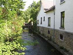 The Orneau flowing through Mazy | |
 Mazy | |
| Coordinates: 50°30′41.2″N 4°40′36.1″E / 50.511444°N 4.676694°ECoordinates: 50°30′41.2″N 4°40′36.1″E / 50.511444°N 4.676694°E | |
| Country |
|
| Province | Namur |
| Municipality | Gembloux |
| Elevation | 112 m (367 ft) |
| Time zone | UTC+1 (CET) |
Mazy (Walloon: Mazi) is a village on the Orneau (a tributary of the Sambre), located about 5 kilometres (3.1 mi) south of the city of Gembloux, in province of Namur in the Walloon region of Belgium.[1][2]
Falnuée Castle, currently a golf clubhouse, is located in Mazy.[3][4]
References
- ↑
"Mazy Map — Satellite Images of Mazy". MapLandia.com. Retrieved August 2014. Check date values in:
|accessdate=(help) - ↑ "Contrats de rivière en Wallonie - Sambre". Environnement.wallonie.be. Retrieved July 2014. Check date values in:
|accessdate=(help) - ↑ "Ferme-château de Falnuée (Club-house du Golf) à Mazy - 5032". Retrieved August 2014. Check date values in:
|accessdate=(help) - ↑ "Falnuée Golf". Archived from the original on 2014-08-10. Retrieved August 2014. Check date values in:
|accessdate=(help)
External links
- "Château-ferme de Falnuée, Mazy". panoramio.com. — picture of the castle.
This article is issued from
Wikipedia.
The text is licensed under Creative Commons - Attribution - Sharealike.
Additional terms may apply for the media files.