Maxwell Park, Oakland, California
Coordinates: 37°46′45″N 122°11′45″W / 37.77917°N 122.19583°W
| Maxwell Park | |
|---|---|
| Neighborhood of Oakland | |
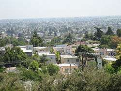 A view over Maxwell Park | |
 Location of Maxwell Park in Oakland | |
| Coordinates: 37°46′45″N 122°11′45″W / 37.779167°N 122.195833°W | |
| Country | United States |
| State | California |
| County | Alameda |
| City | Oakland |
Maxwell Park is a neighborhood in Oakland, California located in the foothills of the city. It is geographically bordered by MacArthur Blvd, High Street, Trask Street, Foothill Blvd, and 55th Avenue and is adjacent to Mills College, I-580, Brookdale Park, and the Fairfax neighborhood. It lies at an elevation of from 138 feet to its highest point of 266 feet on Knowland Ave (42 m).
Many of the homes in the neighborhood have panoramic views of the Oakland Hills to the north, Alameda and the San Francisco Bay to the west.
History
The area is named after its developer, John P. Maxwell. The original development area was bounded by 55th Avenue, Trask Street, Monticello Avenue and Camden Street.
The land was opened zoned for development on May 7, 1921 and Burritt and Shealey, the main developers were the same developers from many of the homes in the nearby upscale enclave of Piedmont.
Nearby streetcar transportation and a salubrious climate were cardinal selling points. It is in East Oakland's justly famed 'warm belt'. The streetcars were replaced by AC Transit buses in 1960. Lines 47 and 14 service the neighborhood to and from the Fruitvale BART station, along with many other lines that run along MacArthur Blvd.
Notable Places
- Maxwell Park (a city park)
- Fremont High School
- Home of Peace Cemetery
- Mills College
- Melrose Leadership Academy
- Urban Montessori Charter School
- Courtland Creek
See also
References
External links
- Maxwell Park Neighborhood Council official website.
- "Neighborhood Search Map". Oakland Museum of California. Archived from the original on 2009-04-30. Retrieved 2011-07-29.