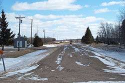
Mavie, Minnesota
| Mavie, Minnesota | |
|---|---|
| Unincorporated community | |
 | |
 Mavie, Minnesota  Mavie, Minnesota | |
| Coordinates: 48°08′41″N 95°56′20″W / 48.14472°N 95.93889°WCoordinates: 48°08′41″N 95°56′20″W / 48.14472°N 95.93889°W | |
| Country | United States |
| State | Minnesota |
| County | Pennington |
| Elevation | 1,161 ft (354 m) |
| Population [1] | |
| • Total | 20 |
| Time zone | UTC-6 (Central (CST)) |
| • Summer (DST) | UTC-5 (CDT) |
| Area code(s) | 218 |
| GNIS feature ID | 647625[2] |
Mavie is an unincorporated community in the township of Clover Leaf, Pennington County, Minnesota, United States.[2]
Notes
- ↑ General Highway Map: Pennington County, Minnesota (PDF) (Map). Minnesota Department of Transportation. 2015. Retrieved June 7, 2016.
- 1 2 "Mavie, Minnesota". Geographic Names Information System. United States Geological Survey.
Municipalities and communities of Pennington County, Minnesota, United States | ||
|---|---|---|
| Cities | 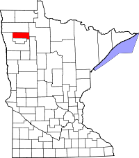 | |
| Townships | ||
| Unincorporated communities | ||
| Indian reservation | ||
| Footnotes | ‡This populated place also has portions in an adjacent county or counties | |
This article is issued from
Wikipedia.
The text is licensed under Creative Commons - Attribution - Sharealike.
Additional terms may apply for the media files.