Erie, Minnesota
| Erie, Minnesota | |
|---|---|
| Unincorporated community | |
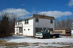 Building in Erie | |
 Erie, Minnesota  Erie, Minnesota | |
| Coordinates: 48°04′13″N 95°43′19″W / 48.0702386°N 95.7219580°WCoordinates: 48°04′13″N 95°43′19″W / 48.0702386°N 95.7219580°W | |
| Country | United States |
| State | Minnesota |
| County | Pennington |
| Elevation | 1,171 ft (357 m) |
| Time zone | UTC-6 (Central (CST)) |
| • Summer (DST) | UTC-5 (CDT) |
| Area code(s) | 218 |
| GNIS feature ID | 1989114[1] |
Erie is a small unincorporated community in Pennington County, Minnesota, United States.[1] The community was home to local businesses until the late 20th century with the closing of its last store, Sjulstad Store.
A post office called Erie was established in 1905, and remained in operation until 1938.[2] The community was named after Erie, Pennsylvania.[3]
References
- 1 2 U.S. Geological Survey Geographic Names Information System: Erie
- ↑ "Pennington County". Jim Forte Postal History. Retrieved 29 July 2015.
- ↑ Upham, Warren (1920). Minnesota Geographic Names: Their Origin and Historic Significance. Minnesota Historical Society. p. 406.
Municipalities and communities of Pennington County, Minnesota, United States | ||
|---|---|---|
| Cities | 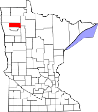 | |
| Townships | ||
| Unincorporated communities | ||
| Indian reservation | ||
| Footnotes | ‡This populated place also has portions in an adjacent county or counties | |
This article is issued from
Wikipedia.
The text is licensed under Creative Commons - Attribution - Sharealike.
Additional terms may apply for the media files.