Maullín River
| Maullín River | |
|---|---|
 | |
| Country | Chile |
| Physical characteristics | |
| Main source | Llanquihue Lake |
| River mouth | Pacific Ocean |
| Length | 85 km (53 mi)[1] |
| Basin features | |
| Basin size | 3,972 km2 (1,534 sq mi)[1] |
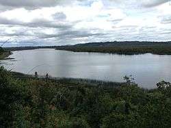
Maullín River is a river of Chile located in the Los Lagos Region. The river originates as the outflow of Llanquihue Lake, and flows generally southwestward, over a number of small waterfalls, emptying into the Gulf of Coronados.[2] The lower course of the river is a tidal estuary.
History
The river was first explored extensively in 1856 and 1857 by the Chilean Navy officers Francisco Hudson and Francisco Vidal Gormaz. The area around Llanquihue Lake was settled in this period by German immigrants, who received land from the government in a scheme to encourage settlement in this area. A total of 6,000 German immigrants settled in this region of southern Chile from 1850 to 1875.
References
- 1 2 "Cuenca del río Maullín" (PDF). Retrieved 5 July 2018.
- ↑ Image Science and Analysis Laboratory, NASA-Johnson Space Center. NM23-720-597 "Maullin River, Puerto Montt," Chile, Winter/Spring 1997 Archived 2003-04-08 at the Wayback Machine., (16 July 2007)
This article is issued from
Wikipedia.
The text is licensed under Creative Commons - Attribution - Sharealike.
Additional terms may apply for the media files.