Massachusetts Route 47
| ||||
|---|---|---|---|---|
 | ||||
| Route information | ||||
| Maintained by MassDOT | ||||
| Length | 21.93 mi[1] (35.29 km) | |||
| Major junctions | ||||
| South end |
| |||
|
| ||||
| North end |
| |||
| Location | ||||
| Counties | Hampshire, Franklin | |||
| Highway system | ||||
| ||||

Route 47 is a north–south state highway in the Pioneer Valley region of the U.S. state of Massachusetts.
Route description
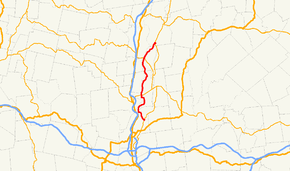
Route 47 begins at Route 116 in South Hadley near the northwest corner of the Mount Holyoke College campus. It heads northwestward towards the southwest corner of Hadley, crossing into that town near the Hockanum Flat, a bend in the Connecticut River. It then follows within half a mile of the river before turning onto Middle Street, crossing through the town center and intersecting Route 9 just over a mile east of the Calvin Coolidge Bridge into Northampton.
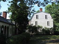
Route 47 turns right when Middle Street meets the river again, following the river's path into the North Hadley section of town, passing the Porter-Phelps-Huntington House and the North Hadley Sugar Shack along the way. It then passes into the town of Sunderland. In Sunderland it continues along the east banks of the river, intersecting Route 116 once more in that town's center, just east of the Sunderland Bridge. It then bends northeastward, and ends just a half-mile into the Montague Center village of Montague at Route 63.
Junction list
| County | Location | mi | km | Destinations | Notes |
|---|---|---|---|---|---|
| Hampshire | South Hadley | 0.00 | 0.00 | Southern terminus of Route 47. | |
| Hadley | 7.7 | 12.4 | Route 9 West to Calvin Coolidge Bridge across Connecticut River. Route 9 East to UMass Amherst. | ||
| Franklin | Sunderland | 17.1 | 27.5 | Route 116 West to Sunderland Bridge across Connecticut River. | |
| Montague | 21.93 | 35.29 | Northern terminus of Route 47. | ||
| 1.000 mi = 1.609 km; 1.000 km = 0.621 mi | |||||
References
Route map:
| Wikimedia Commons has media related to Massachusetts Route 47. |