Massachusetts Route 198
| ||||
|---|---|---|---|---|
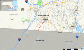 Map of Worcester County in central Massachusetts with Route 198 highlighted in red | ||||
| Route information | ||||
| Maintained by MassDOT | ||||
| Length | 3.96 mi[1] (6.37 km) | |||
| Major junctions | ||||
| South end |
| |||
| North end |
| |||
| Location | ||||
| Counties | Worcester | |||
| Highway system | ||||
| ||||

Route 198 is a state highway in the U.S. state of Massachusetts. The highway runs 3.960 miles (6.373 km) from the Connecticut state line north to Route 131 within Southbridge in southern Worcester County.
Route description
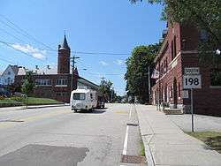
Southbound Route 198 near its northern terminus
Route 198 begins along Eastford Road at the Connecticut state line, from which the road continues south as Connecticut Route 198 into Woodstock. The two-lane highway heads north through the town of Southbridge. At the south end of the town center, Route 198 has an oblique intersection with Elm Street, and the state highway assumes that name to its northern terminus at Route 131 (Main Street).[1]
Major intersections
The entire route is in Southbridge, Worcester County.
| mi[1] | km | Destinations | Notes | ||
|---|---|---|---|---|---|
| 0.000 | 0.000 | Southern terminus; Connecticut state line | |||
| 3.960 | 6.373 | Northern terminus | |||
| 1.000 mi = 1.609 km; 1.000 km = 0.621 mi | |||||
References
- 1 2 3 Planning Division (2012). "Massachusetts Highway Route Log". Massachusetts Department of Transportation. Retrieved February 11, 2017.
External links
Route map:
This article is issued from
Wikipedia.
The text is licensed under Creative Commons - Attribution - Sharealike.
Additional terms may apply for the media files.