Massachusetts Route 197
| ||||
|---|---|---|---|---|
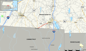 Map of Worcester County in central Massachusetts with Route 197 highlighted in red | ||||
| Route information | ||||
| Maintained by MassDOT | ||||
| Length | 3.20 mi[1] (5.15 km) | |||
| Major junctions | ||||
| South end |
| |||
| North end |
| |||
| Location | ||||
| Counties | Worcester | |||
| Highway system | ||||
| ||||

Route 197 is a state highway in the U.S. state of Massachusetts. The highway runs 3.200 miles (5.150 km) from the Connecticut state line north to Route 12 within Dudley in southern Worcester County.
Route description
Route 197 begins at an oblique crossing of the Connecticut state line, from which Connecticut Route 197 continues into the village of Quinebaug in the town of Thompson. The state line crossing is a short distance east of the southern terminus of Massachusetts Route 31. The two-lane highway heads northeast as Main Street through the town of Dudley and passes to the south of Nichols College. Route 197 passes to the south of Merino Lake before reaching its eastern terminus at a four-way intersection with Route 12 and Village Street. Route 12 heads south along Schofield Street toward Connecticut and east along Main Street across the French River into Webster.[1]
Major intersections
The entire route is in Dudley, Worcester County.
| mi[1] | km | Destinations | Notes | ||
|---|---|---|---|---|---|
| 0.00 | 0.00 | Southern terminus; Connecticut state line | |||
| 3.200 | 5.150 | Northern terminus | |||
| 1.000 mi = 1.609 km; 1.000 km = 0.621 mi | |||||
References
- 1 2 3 Planning Division (2012). "Massachusetts Highway Route Log". Massachusetts Department of Transportation. Retrieved February 11, 2017.
External links
Route map: