Mascota
| Mascota, Jalisco | ||
|---|---|---|
| Municipality and City | ||
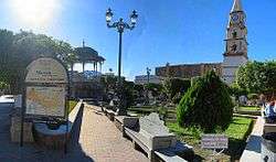 Image of Mascota, Jalisco. | ||
| ||
 | ||
|
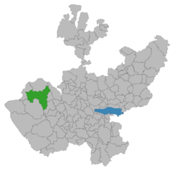
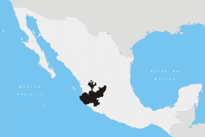
Mascota, Jalisco Location in Mexico | ||
| Coordinates: 20°31′24.6371″N 104°47′19.0432″W / 20.523510306°N 104.788623111°WCoordinates: 20°31′24.6371″N 104°47′19.0432″W / 20.523510306°N 104.788623111°W | ||
| Country |
| |
| State | Jalisco | |
| Government | ||
| • Mayor | Miguel Castillon Lopez | |
| Area | ||
| • Total | 1,591 km2 (614 sq mi) | |
| Elevation | 1,268 m (4,160 ft) | |
| Population (2013) | ||
| • Total | 104,045 | |
| Postal Code | 46900 | |
| Area code(s) | 388 | |
| Website | http://www.mascota.jalisco.gob.mx/index.html | |

Mascota is a town and municipality in Jalisco, in central-western Mexico. The municipality covers an area of 1,591.63 km². The municipality has smaller villages such as Tecuani and La Plata, both a couple miles away. Mascota is surrounded by roads and pine-covered mountains and is a usual stop on the road to Talpa De Allende or Puerto Vallarta.
As of 2005, the municipality had a total population of 14,045.[1]
Climate
| Climate data for Mascota | |||||||||||||
|---|---|---|---|---|---|---|---|---|---|---|---|---|---|
| Month | Jan | Feb | Mar | Apr | May | Jun | Jul | Aug | Sep | Oct | Nov | Dec | Year |
| Average high °C (°F) | 27 (81) |
28 (82) |
30 (86) |
32 (90) |
32 (90) |
32 (90) |
30 (86) |
30 (86) |
30 (86) |
30 (86) |
29 (84) |
28 (82) |
30 (86) |
| Average low °C (°F) | 8 (46) |
8 (46) |
8 (46) |
10 (50) |
13 (55) |
18 (64) |
19 (66) |
19 (66) |
19 (66) |
17 (63) |
12 (54) |
9 (48) |
13 (56) |
| Average precipitation mm (inches) | 29 (1.14) |
16 (0.63) |
2 (0.08) |
1 (0.04) |
7 (0.28) |
156 (6.14) |
275 (10.83) |
275 (10.83) |
200 (7.87) |
93 (3.66) |
9 (0.35) |
13 (0.51) |
1,076 (42.36) |
| Average precipitation days | 4 | 3 | 1 | 1 | 1 | 13 | 24 | 24 | 23 | 10 | 2 | 2 | 108 |
| Source: [2] | |||||||||||||
References
- ↑ "Mascota". Enciclopedia de los Municipios de México. Instituto Nacional para el Federalismo y el Desarrollo Municipal. Retrieved April 16, 2009.
- ↑ "Mascota, Mexico Weather Averages". World Weather Online. Retrieved January 27, 2015.
This article is issued from
Wikipedia.
The text is licensed under Creative Commons - Attribution - Sharealike.
Additional terms may apply for the media files.