Masca
| Masca | |
|---|---|
 Masca in Tenerife | |
 Masca Location in the Canary Islands | |
| Coordinates: 28°18′19″N 16°50′25″W / 28.30528°N 16.84028°WCoordinates: 28°18′19″N 16°50′25″W / 28.30528°N 16.84028°W | |
| Country |
|
| Autonomous community |
|
| Province | Santa Cruz de Tenerife |
| Island | Tenerife |
| Municipality | Buenavista del Norte |
| Population (2013)[1] | |
| • Total | 99 |
| Time zone | WET |
| • Summer (DST) | WEST |
| Official language(s) | Spanish |

View of La Gomera from Masca
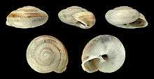
Shell of Hemicycla mascaensis, an endemic land snail of Tenerife, named after the village of Masca
Masca is a small mountain village on the island of Tenerife. The village is home to around 90 inhabitants. The village lies at an altitude of 650 m in the Macizo de Teno mountains, which extend up to the northwesternmost point of Tenerife.
Forests including cypresses and palm trees abound. The village lies at the head of the Masca Gorge. The trail from the village down the gorge to the beach on the Atlantic Ocean is a popular, though strenuous, hiking route, which takes about 3 hours each way.[2]
References
- ↑ Instituto Canario de Estadística Archived 2014-04-16 at the Wayback Machine.
- ↑ Klaus Wolfsperger (2010). Tenerife. Rother Walking Guides. pp. 88 to 91. ISBN 978-3-7633-4809-1.
External links
| Wikimedia Commons has media related to Masca. |
This article is issued from
Wikipedia.
The text is licensed under Creative Commons - Attribution - Sharealike.
Additional terms may apply for the media files.