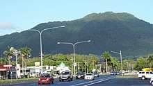
Manunda, Queensland
| Manunda Cairns, Queensland | |||||||||||||||
|---|---|---|---|---|---|---|---|---|---|---|---|---|---|---|---|
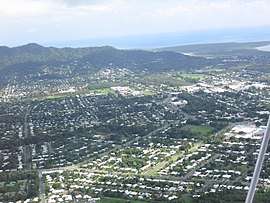 Aerial view over Manunda.jpg | |||||||||||||||
 Manunda | |||||||||||||||
| Coordinates | 16°55′09″S 145°44′54″E / 16.9191°S 145.7483°ECoordinates: 16°55′09″S 145°44′54″E / 16.9191°S 145.7483°E | ||||||||||||||
| Population | 5,390 (2016 census)[1] | ||||||||||||||
| • Density | 1,198/km2 (3,100/sq mi) | ||||||||||||||
| Postcode(s) | 4870 | ||||||||||||||
| Area | 4.5 km2 (1.7 sq mi) | ||||||||||||||
| LGA(s) | Cairns Region | ||||||||||||||
| State electorate(s) | Cairns | ||||||||||||||
| Federal Division(s) | Leichhardt | ||||||||||||||
| |||||||||||||||
Manunda is a suburb of Cairns in the Cairns Region, Queensland, Australia.[2] In 2016 census, the population of Manunda was 5,390.[1]
Geography
Manunda is a flat suburb (0-10 metres above sea level). The southern part of Manunda is residential while the northern part contains a number of community amenities including sportsgrounds and the Cairns Cemetery (also known as Martyn Street Cemetery). In-between is an commercial/industrial estate flanking Anderson Street.[3]
History
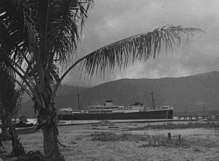
Manunda was named by Queensland Place Names Board on 1 September 1973 after TSMV Manunda of the Adelaide Steamship Company which regularly visited Cairns.[2] In 1975 the neighbouring suburb of Manoora was named for Manunda's sister ship HMAS Manoora.[4]
Manunda is home to many schools.The Cairns Seventh Day Adventist School opened on 6 February 1950. Trinity Bay State High School opened on 25 January 1960. Cairns West State School opened on 28 January 1964. St Francis Xavier's School opened on 23 January 1967.[5]
Manunda Library opened in 1991 and underwent a major refurbishment in 2007.[6]
Cairns School of Distance Education opened 20 July 1974. Emmanuel College opened in Manunda on 29 January 1986. On 4 February 1991 Trinity Bay Centre for Continuing Secondary Education was established, conducting night classes at Trinity Bay State High School.[5]
In 2002 Emmanual College closed and became Djarragun College, a school committed to improving the educational outcomes of Indigenous students in the Cape York area.[7][8]
Notable people buried in Martyn Street Cemetery
- Bunny Adair, Member of the Queensland Legislative Assembly for Cook
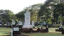 Headstones, Martyn Street cemetery, 2018
 - Leonard John Brass, botanist and explorer
- Ray Jones, Member of the Queensland Legislative Assembly for Cairns
- Andrew Leon (also known as Andrew Lee On and Leong Chong), established the first sugar plantation and sugar mill in North Queensland
- John Mann, Member of the Queensland Legislative Assembly for Cairns
- Thomas Nevitt, Member of the Queensland Legislative Council and the Queensland Legislative Assembly for Carpentaria
- Percy Pease, Member of the Queensland Legislative Assembly for Herbert
- Watty Wallace, Member of the Queensland Legislative Assembly for Cairns
Facilities
Cairns Regional Council operates a library service in Manunda, located in the Raintrees shopping Centre[9].
References
- 1 2 Australian Bureau of Statistics (27 June 2017). "Manunda (State Suburb)". 2016 Census QuickStats. Retrieved 18 April 2018.

- 1 2 "Manunda - suburb in Cairns Region (entry 48742)". Queensland Place Names. Queensland Government. Retrieved 5 August 2017.
- ↑ "Queensland Globe". State of Queensland. Retrieved 29 September 2017.
- ↑ "Manoora - suburb in Cairns Region (entry 48741)". Queensland Place Names. Queensland Government. Retrieved 26 June 2017.
- 1 2 Queensland Family History Society (2010), Queensland schools past and present (Version 1.01 ed.), Queensland Family History Society, ISBN 978-1-921171-26-0
- ↑ "Public Libraries Statistical Bulletin 2016-17" (PDF). Public Libraries Connect. State Library of Queensland. November 2017. p. 12. Archived (PDF) from the original on 30 January 2018. Retrieved 30 January 2018.
- ↑ "Historical details for ABN 58 063 049 669". Department of Industry. Australian Government. 1 November 2017. Archived from the original on 29 September 2017. Retrieved 29 September 2017.
- ↑ "Djarragun College". Cape York Partnership. Archived from the original on 29 September 2017. Retrieved 29 September 2017.
- ↑ "Manunda Library". Public Libraries Connect. Retrieved 2 February 2018.
External links
![]()
- "Manunda". Queensland Places. Centre for the Government of Queensland, University of Queensland.